2017-02-08 47 11
From Geohashing
Revision as of 17:24, 8 February 2017 by imported>Rincewind (→Plans)
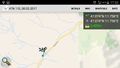
| Wed 8 Feb 2017 in 47,11: 47.0740375, 11.7563917 geohashing.info google osm bing/os kml crox |
Location
Participants
Rincewind (talk) and a ninja-dragalong
Plans
For the last couple of vacations here, I've more or less constantly checked coordinates, but they never seemed reachable as a side activity, or not at all. In the alps, "not reachable" is happening more often than not in winter. Yesterday I saw that the coordinates fall exactly onto a spot at the end of B169 road- which means federal road and hence, has winter service. That looked promising... It was exactly at the other side of the mountain chain where we were skiing, of course, but you can't have everything. So the plan was to simply get my first Austria hash and drag my snowboard wielding friend along.
Expedition
Tracklog
Photos
Successful Austria hash. :)

XKCD was here... (Chalk paint)


Achievements