Difference between revisions of "2017-02-18 49 8"
From Geohashing
imported>Rincewind m (→Participants) |
imported>Rincewind (→Photos) |
||
| Line 41: | Line 41: | ||
--> | --> | ||
<gallery perrow="5"> | <gallery perrow="5"> | ||
| − | + | Image:2017-02-18 49 8 hashproof.jpg|GPS doodad screenshot | |
| − | Image:2017-02-18_49_8_Rincewind_1487438488544.jpg| | + | Image:2017-02-18 49 8 hashgrin.jpg|Stupid grin(TM) |
| + | Image:2017-02-18_49_8_Rincewind_1487438488544.jpg|Distance from parking spot | ||
</gallery> | </gallery> | ||
Revision as of 18:53, 18 February 2017
| Sat 18 Feb 2017 in 49,8: 49.7858425, 8.6326259 geohashing.info google osm bing/os kml crox |
Location
A mere 2.8km as the bird flies (and 5km as the car drives...) next to federal road B3. Can't not go. :)
Participants
Plans
Expedition
Tracklog
Photos
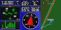
GPS doodad screenshot

Stupid grin(TM)

Distance from parking spot


Achievements