Difference between revisions of "2017-03-15 49 8"
From Geohashing
imported>DODO (Created page with "{{subst:Expedition |lat = 49 |lon = 8 |date = 2016-03-15 }}") |
imported>DODO |
||
| Line 12: | Line 12: | ||
| lat=49 | | lat=49 | ||
| lon=8 | | lon=8 | ||
| − | | date= | + | | date=2017-03-15 |
}} | }} | ||
| Line 20: | Line 20: | ||
== Location == | == Location == | ||
<!-- where you've surveyed the hash to be --> | <!-- where you've surveyed the hash to be --> | ||
| + | In a nurserynext to Schifferstadt | ||
== Participants == | == Participants == | ||
<!-- who attended: If you link to your wiki user name in this section, your expedition will be picked up by the various statistics generated for geohashing. You may use three tildes ~ as a shortcut to automatically insert the user signature of the account you are editing with. | <!-- who attended: If you link to your wiki user name in this section, your expedition will be picked up by the various statistics generated for geohashing. You may use three tildes ~ as a shortcut to automatically insert the user signature of the account you are editing with. | ||
--> | --> | ||
| + | [[User:DODO|DODO]] | ||
== Plans == | == Plans == | ||
<!-- what were the original plans --> | <!-- what were the original plans --> | ||
| + | Go there by bull on my way to the office. | ||
== Expedition == | == Expedition == | ||
<!-- how it all turned out. your narrative goes here. --> | <!-- how it all turned out. your narrative goes here. --> | ||
| − | + | I haven't been hashing for a while and when I saw this hash so close to home I couldn't resist although it was probably posted. Well, things went pretty much as planned: I came close to the hash, but a fence stopped me 17 m before I reached my aim. I took some pictures and continued my way to the office, using the ferry in Altrip once again. There was a path behind the nursery that I just added on OSM. | |
== Tracklog == | == Tracklog == | ||
<!-- if your GPS device keeps a log, you may post a link here --> | <!-- if your GPS device keeps a log, you may post a link here --> | ||
| − | + | [https://www.komoot.de/tour/14710282 32 KM by bull (and ferry)] | |
== Photos == | == Photos == | ||
<!-- Insert pictures between the gallery tags using the following format: | <!-- Insert pictures between the gallery tags using the following format: | ||
| Line 39: | Line 42: | ||
--> | --> | ||
<gallery perrow="5"> | <gallery perrow="5"> | ||
| + | Image:2017-03-15_49_8-1.jpg|17 m to go. The fence and the nursery. | ||
| + | Image:2017-03-15_49_8-2.jpg|bull next to the fence | ||
| + | Image:2017-03-15_49_8-3.jpg|unhappy hasher | ||
| + | Image:2017-03-15_49_8-4.jpg|ferry | ||
| + | Image:2017-03-15_49_8-5.png|proof of failure | ||
</gallery> | </gallery> | ||
| Line 46: | Line 54: | ||
<!-- =============== USEFUL CATEGORIES FOLLOW ================ | <!-- =============== USEFUL CATEGORIES FOLLOW ================ | ||
| − | + | {{OpenStreetMap achievement | |
| − | + | | latitude = 49 | |
| + | | longitude = 8 | ||
| + | | date = 2017-03-15 | ||
| + | | OSMlink = 46938881 | ||
| + | | name = DODO | ||
| + | }} | ||
| − | + | {{No trespassing | |
| − | + | | latitude = 49 | |
| − | + | | longitude = 8 | |
| − | + | | date = 2016-12-11 | |
| − | + | | name = DODO | |
| − | + | | distance = 9m | |
| − | + | }} | |
| − | |||
[[Category:Expeditions]] | [[Category:Expeditions]] | ||
| − | |||
| − | |||
| − | |||
| − | |||
| − | |||
| − | |||
| − | |||
| − | |||
| − | |||
| − | |||
| − | |||
[[Category:Coordinates not reached]] | [[Category:Coordinates not reached]] | ||
| − | |||
| − | |||
| − | |||
| − | |||
| − | |||
[[Category:Not reached - No public access]] | [[Category:Not reached - No public access]] | ||
| − | |||
| − | |||
| − | |||
| − | |||
| − | |||
| − | |||
| − | |||
| − | |||
Revision as of 19:27, 17 March 2017
| Wed 15 Mar 2017 in 49,8: 49.3915635, 8.3954586 geohashing.info google osm bing/os kml crox |
Location
In a nurserynext to Schifferstadt
Participants
Plans
Go there by bull on my way to the office.
Expedition
I haven't been hashing for a while and when I saw this hash so close to home I couldn't resist although it was probably posted. Well, things went pretty much as planned: I came close to the hash, but a fence stopped me 17 m before I reached my aim. I took some pictures and continued my way to the office, using the ferry in Altrip once again. There was a path behind the nursery that I just added on OSM.
Tracklog
Photos
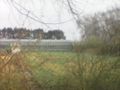
17 m to go. The fence and the nursery.
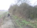
bull next to the fence

unhappy hasher
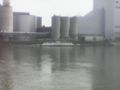
ferry
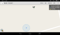
proof of failure


