Difference between revisions of "2017-03-23 51 9"
From Geohashing
imported>GeorgDerReisende (new report) |
imported>GeorgDerReisende (expedition report for Habichtswald-Dörnberg) |
||
| Line 1: | Line 1: | ||
| − | |||
| − | |||
| − | |||
| − | |||
| − | |||
| − | |||
| − | |||
| − | |||
| − | |||
| − | |||
{{meetup graticule | {{meetup graticule | ||
| lat=51 | | lat=51 | ||
| Line 19: | Line 9: | ||
== Location == | == Location == | ||
| − | + | ||
| + | The hash lay on a small hill southeast of Dörnberg. | ||
== Participants == | == Participants == | ||
| − | + | ||
| − | + | [[User:GeorgDerReisende|GeorgDerReisende]] | |
== Plans == | == Plans == | ||
| − | + | ||
| + | I wanted to travel by bus to the tavern ''Ahnetal'' and walking to the hash. | ||
== Expedition == | == Expedition == | ||
| − | |||
| − | + | I took the bus 110 until the stop Ahnetal. Then I walked through the forest and through the fields above Dörnberg. I found the hash on the small hill, but behind a fence. I couldn't see the reason for the fence. I walked around the area and there was no hole. | |
| − | |||
== Photos == | == Photos == | ||
| Line 39: | Line 29: | ||
--> | --> | ||
<gallery perrow="5"> | <gallery perrow="5"> | ||
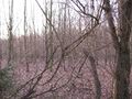
| + | Image:2017-03-23 51 9 GeorgDerReisende 1641.jpg | 25 meters to hash | ||
| + | Image:2017-03-23 51 9 GeorgDerReisende 1642.jpg | the unhappy geohasher | ||
| + | Image:2017-03-23 51 9 GeorgDerReisende 1674.jpg | the small hill | ||
</gallery> | </gallery> | ||
| − | + | [[Category:Expeditions]] | |
| − | |||
| − | |||
| − | |||
| − | |||
| − | |||
| − | |||
| − | |||
| − | |||
| − | |||
| − | |||
| − | |||
| − | |||
| − | |||
| − | |||
| − | |||
| − | |||
| − | |||
| − | |||
[[Category:Expeditions with photos]] | [[Category:Expeditions with photos]] | ||
| − | |||
| − | |||
| − | |||
| − | |||
| − | |||
| − | |||
| + | [[Category:Coordinates not reached]] | ||
| − | |||
| − | |||
| − | |||
| − | |||
| − | |||
| − | |||
| − | |||
[[Category:Not reached - No public access]] | [[Category:Not reached - No public access]] | ||
| − | |||
| − | |||
| − | |||
| − | |||
| − | |||
| − | |||
| − | |||
| − | |||
Revision as of 21:34, 23 March 2017
| Thu 23 Mar 2017 in 51,9: 51.3394216, 9.3653736 geohashing.info google osm bing/os kml crox |
Location
The hash lay on a small hill southeast of Dörnberg.
Participants
Plans
I wanted to travel by bus to the tavern Ahnetal and walking to the hash.
Expedition
I took the bus 110 until the stop Ahnetal. Then I walked through the forest and through the fields above Dörnberg. I found the hash on the small hill, but behind a fence. I couldn't see the reason for the fence. I walked around the area and there was no hole.
Photos
25 meters to hash
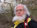
the unhappy geohasher
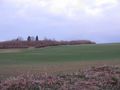
the small hill


