Difference between revisions of "2017-06-02 47 -119"
From Geohashing
imported>FippeBot m (Location) |
imported>Thomcat |
||
| Line 27: | Line 27: | ||
== Plans == | == Plans == | ||
<!-- what were the original plans --> | <!-- what were the original plans --> | ||
| + | Okay, wow, this is an old one. Plans were to drive across the state on highway 2 and stop at the geohashpoint. Zeke's drive-in was the first stop on the way. | ||
== Expedition == | == Expedition == | ||
<!-- how it all turned out. your narrative goes here. --> | <!-- how it all turned out. your narrative goes here. --> | ||
| + | I do remember this spot had no internet whatsoever - and the "plunger" message refers to the app being stuck so I couldn't send any messages (or wikiedits). So time to dig up the camera and see what it shows - including hopefully a screenshot. I did achieve the geohash on the subsequent day, so it is likely - but we shall see... | ||
Revision as of 05:11, 1 August 2019
| Fri 2 Jun 2017 in 47,-119: 47.6104995, -119.8721256 geohashing.info google osm bing/os kml crox |
Location
Participants
Plans
Okay, wow, this is an old one. Plans were to drive across the state on highway 2 and stop at the geohashpoint. Zeke's drive-in was the first stop on the way.
Expedition
I do remember this spot had no internet whatsoever - and the "plunger" message refers to the app being stuck so I couldn't send any messages (or wikiedits). So time to dig up the camera and see what it shows - including hopefully a screenshot. I did achieve the geohash on the subsequent day, so it is likely - but we shall see...
- On the way -- Thomcat (talk) @47.8553,-121.8907 14:49, 2 June 2017 (PDT)
Tracklog
Photos
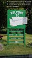
Zekesville @47.8338,-121.6424
