Difference between revisions of "2017-06-12 55 37"
From Geohashing
imported>Vb (Created page with "{{subst:Expedition |lat = 55 |lon = 37 |date = 2017-06-12 }}") |
|||
| (2 intermediate revisions by 2 users not shown) | |||
| Line 1: | Line 1: | ||
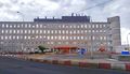
| + | [[Image:{{{image|2017-06-12_55_37_vb_20170612_160621_HDR.jpg}}}|800px|right]] | ||
| − | |||
| − | |||
| − | |||
| − | |||
| − | |||
| − | |||
| − | |||
| − | |||
| − | |||
{{meetup graticule | {{meetup graticule | ||
| lat=55 | | lat=55 | ||
| Line 19: | Line 11: | ||
== Location == | == Location == | ||
| − | + | 1st Kotlyakovskiy pereulok, at the edge of "Kotlyakovo" industrial zone, in Tsaritsino district. | |
== Participants == | == Participants == | ||
| − | + | [[User:Vb|vb]] | |
| − | -- | + | |
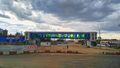
| + | == Expedition == | ||
| + | [[Image:{{{image|2017-06-12_55_37_vb_Capture%2B_2017-06-12-16-06-00.jpg}}}|300px]] | ||
| − | + | The place now is a construction site for the new road. The hash is inside the pit on the photo. Closest I could get was 20.5m. | |
| − | |||
| − | + | Bicycle (30km), tron. | |
| − | |||
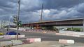
== Tracklog == | == Tracklog == | ||
<!-- if your GPS device keeps a log, you may post a link here --> | <!-- if your GPS device keeps a log, you may post a link here --> | ||
| + | [[Image:{{{image|2017-06-12_55_37_vb_2017-06-13_13_46_08-Clipboard.jpg}}}|500px]] | ||
== Photos == | == Photos == | ||
| − | |||
| − | |||
| − | |||
<gallery perrow="5"> | <gallery perrow="5"> | ||
| + | Image:2017-06-12_55_37_vb_20170612_155709.jpg | Shoes factory near the hash. Weirdly, "Shoes factory" is their trademark - mostly for the chain of shops, but this is the actual factory. | ||
| + | Image:2017-06-12_55_37_vb_20170612_155942_HDR.jpg | ||
| + | Image:2017-06-12_55_37_vb_20170612_163516.jpg | What seems to be the other end of the road under construction, in Chertanovo district. | ||
</gallery> | </gallery> | ||
| − | |||
| − | |||
| − | |||
| − | |||
| − | |||
| − | |||
| − | |||
| − | |||
| − | |||
| − | |||
| − | |||
| − | |||
| − | |||
| − | |||
| − | |||
| − | |||
| − | |||
| − | |||
[[Category:Expeditions]] | [[Category:Expeditions]] | ||
| − | |||
[[Category:Expeditions with photos]] | [[Category:Expeditions with photos]] | ||
| − | |||
| − | |||
| − | |||
| − | |||
| − | |||
| − | |||
| − | |||
| − | |||
| − | |||
[[Category:Coordinates not reached]] | [[Category:Coordinates not reached]] | ||
| − | |||
| − | |||
| − | |||
| − | |||
| − | |||
[[Category:Not reached - No public access]] | [[Category:Not reached - No public access]] | ||
| − | + | {{location|RU|MOW}} | |
| − | |||
| − | |||
| − | |||
| − | |||
| − | |||
| − | |||
| − | |||
Latest revision as of 16:51, 8 November 2022

| Mon 12 Jun 2017 in 55,37: 55.6389378, 37.6409199 geohashing.info google osm bing/os kml crox |
Location
1st Kotlyakovskiy pereulok, at the edge of "Kotlyakovo" industrial zone, in Tsaritsino district.
Participants
Expedition

The place now is a construction site for the new road. The hash is inside the pit on the photo. Closest I could get was 20.5m.
Bicycle (30km), tron.
Tracklog

Photos
Shoes factory near the hash. Weirdly, "Shoes factory" is their trademark - mostly for the chain of shops, but this is the actual factory.
What seems to be the other end of the road under construction, in Chertanovo district.


