Difference between revisions of "2017-10-01 47 -121"
imported>Thomcat ([live picture]Not a good sign [http://www.openstreetmap.org/?lat=47.71707200&lon=-121.40846610&zoom=16&layers=B000FTF @47.7171,-121.4085]) |
imported>Thomcat |
||
| Line 1: | Line 1: | ||
| − | |||
| − | |||
| − | |||
| − | |||
| − | |||
| − | |||
| − | |||
| − | |||
| − | |||
| − | |||
{{meetup graticule | {{meetup graticule | ||
| lat=47 | | lat=47 | ||
| lon=-121 | | lon=-121 | ||
| date=2017-10-01 | | date=2017-10-01 | ||
| + | | graticule_name=Snoqualmie | ||
| + | | graticule_link=Snoqualmie, Washington | ||
}} | }} | ||
| Line 19: | Line 11: | ||
== Location == | == Location == | ||
| − | + | Close to a side road off highway 2. | |
== Participants == | == Participants == | ||
<!-- who attended: If you link to your wiki user name in this section, your expedition will be picked up by the various statistics generated for geohashing. You may use three tildes ~ as a shortcut to automatically insert the user signature of the account you are editing with. | <!-- who attended: If you link to your wiki user name in this section, your expedition will be picked up by the various statistics generated for geohashing. You may use three tildes ~ as a shortcut to automatically insert the user signature of the account you are editing with. | ||
--> | --> | ||
| + | * [[User:Thomcat|Thomcat]] | ||
| − | == | + | == Expedition == |
| − | + | I was returning from Leavenworth Oktoberfest, bound for an early evening Seahawks game. In between the two was this hashpoint. Near as I could tell, it was just a few meters from the road, and didn't seem to be on any property (Zillow). | |
| + | |||
| + | Reaching the road, I drove to the nearest spot on the road. The sign I just passed was not encouraging, though the one lane bridge sure seemed to be okay. It was raining moderately at this point. | ||
| − | + | The side of the road dropped off quite a bit, and may have been a creek or stream. Beyond that was more damp undergrowth. I also passed more than one "private property" signs, usually next to a driveway. Finally the hash point distance from the edge of the road was 11m, not just a few. Close enough and yet not close enough, I call this one a miss. | |
| − | |||
== Tracklog == | == Tracklog == | ||
| Line 49: | Line 43: | ||
<!-- Add any achievement ribbons you earned below, or remove this section --> | <!-- Add any achievement ribbons you earned below, or remove this section --> | ||
| − | |||
| − | |||
| − | |||
| − | |||
| − | |||
| − | |||
| − | |||
| − | |||
| − | |||
| − | |||
| − | |||
| − | |||
| − | |||
| − | |||
[[Category:Expeditions]] | [[Category:Expeditions]] | ||
| − | |||
[[Category:Expeditions with photos]] | [[Category:Expeditions with photos]] | ||
| − | |||
| − | |||
| − | |||
| − | |||
| − | |||
| − | |||
| − | |||
| − | |||
| − | |||
[[Category:Coordinates not reached]] | [[Category:Coordinates not reached]] | ||
| − | |||
| − | |||
| − | |||
| − | |||
| − | |||
[[Category:Not reached - No public access]] | [[Category:Not reached - No public access]] | ||
| − | |||
| − | |||
| − | |||
| − | |||
| − | |||
| − | |||
| − | |||
| − | |||
Revision as of 13:21, 3 October 2017
| Sun 1 Oct 2017 in Snoqualmie: 47.7170003, -121.4086566 geohashing.info google osm bing/os kml crox |
Location
Close to a side road off highway 2.
Participants
Expedition
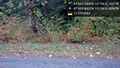
I was returning from Leavenworth Oktoberfest, bound for an early evening Seahawks game. In between the two was this hashpoint. Near as I could tell, it was just a few meters from the road, and didn't seem to be on any property (Zillow).
Reaching the road, I drove to the nearest spot on the road. The sign I just passed was not encouraging, though the one lane bridge sure seemed to be okay. It was raining moderately at this point.
The side of the road dropped off quite a bit, and may have been a creek or stream. Beyond that was more damp undergrowth. I also passed more than one "private property" signs, usually next to a driveway. Finally the hash point distance from the edge of the road was 11m, not just a few. Close enough and yet not close enough, I call this one a miss.
Tracklog
Photos
Close @47.7169,-121.4086
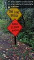
Not a good sign @47.7171,-121.4085

