Difference between revisions of "2018-02-26 54 -1"
(categories) |
|||
| Line 38: | Line 38: | ||
[[Category:Expeditions]] | [[Category:Expeditions]] | ||
[[Category:Coordinates not reached]] | [[Category:Coordinates not reached]] | ||
| + | [[Category:Expeditions with absolutely no photos whatsoever]] | ||
[[Category:Not reached - No public access]] | [[Category:Not reached - No public access]] | ||
| + | [[Category: Geohash inside building]] | ||
{{location|GB|ENG|DUR}} | {{location|GB|ENG|DUR}} | ||
Latest revision as of 20:28, 19 February 2023
| Mon 26 Feb 2018 in 54,-1: 54.6997203, -1.5842698 geohashing.info google osm bing/os kml crox |
I can't believe I reconstructed this five years later, found the date and location. Method: flipping through the hashes from 2017-2018 for one around coordinates 0.7, 0.6 that matches up with my memory of the location in Spennymoor.
My first geohashing run? I have no proof anymore that this happened. Photo and runkeeper log have been lost to the ages.
Location
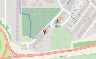
Half Moon Lane, Spennymoor, County Durham, UK
Participants
Plans
A 8.5km run from the south of Durham (17km total out-and-back run).
Expedition
I jogged from Durham to Spennymoor. Getting dark and along highways, for the most part not that pleasant. Discovered some bridges, Croxdale, and Tudhoe/Spennymore. I remember the fork at Tudhoe Cemetery, the community lawn south of it, and finally going up some street of typical residential houses. The hash itself was in a house, did not reach by a few meters.
