Difference between revisions of "2018-04-03 50 7"
From Geohashing
imported>DODO (→Participants) |
imported>DODO (→Plans) |
||
| Line 29: | Line 29: | ||
== Plans == | == Plans == | ||
<!-- what were the original plans --> | <!-- what were the original plans --> | ||
| + | Todays hashpoint is 26,5 KM from my sisters home. As the crow flies. To far, to get there only by foot, especially since I have to walk to a hotel afterwards. I was looking for a bus. There were some from Koblenz via Bendof or Sayn, but none of them convinced me. But then I looked for the nearest station to the hash and found it in the Lahn valley, and I had a quite good connection from Neuwied to Obernhof. | ||
| + | komoot said, it would take 22 KM from Obernhof via the hashpoint to the nearest hotel. Considered the fact that I had to walk more than 6 KM to the station in Neuwied, that is almost 30 KM. A perfect tour for me:-) | ||
== Expedition == | == Expedition == | ||
Revision as of 10:43, 8 April 2018
| Tue 3 Apr 2018 in 50,7: 50.4143468, 7.8831227 geohashing.info google osm bing/os kml crox |
Location
On a field near Heilberscheid in the Westerwald.
Participants
Plans
Todays hashpoint is 26,5 KM from my sisters home. As the crow flies. To far, to get there only by foot, especially since I have to walk to a hotel afterwards. I was looking for a bus. There were some from Koblenz via Bendof or Sayn, but none of them convinced me. But then I looked for the nearest station to the hash and found it in the Lahn valley, and I had a quite good connection from Neuwied to Obernhof. komoot said, it would take 22 KM from Obernhof via the hashpoint to the nearest hotel. Considered the fact that I had to walk more than 6 KM to the station in Neuwied, that is almost 30 KM. A perfect tour for me:-)
Expedition
Tracklog
Photos
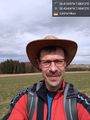
Happy hasher @50.4340,7.9042

Achievements