Difference between revisions of "2018-04-05 35 -81"
From Geohashing
imported>Palmpje m (Show status) |
m |
||
| (6 intermediate revisions by 5 users not shown) | |||
| Line 22: | Line 22: | ||
== Participants == | == Participants == | ||
| − | HashPotato | + | *[[User:HashPotato|HashPotato]] |
== Expedition == | == Expedition == | ||
| − | It was a beautiful drive on a warm spring evening. I drove down the road | + | It was a beautiful drive on a warm spring evening. I drove down the road to the point nearest the hashpoint 170 meters away, took the pictures and left. I stopped at a convenience store near there for a quick snack before returning to the road. |
== Photos == | == Photos == | ||
| Line 32: | Line 32: | ||
--> | --> | ||
<gallery perrow="5"> | <gallery perrow="5"> | ||
| − | Image:2018-04-05-35--81-00.jpg | | + | Image:2018-04-05-35--81-00.jpg | 170 meters off |
Image:2018-04-05-35--81-01.jpg | The gravel road | Image:2018-04-05-35--81-01.jpg | The gravel road | ||
Image:2018-04-05-35--81-02.jpg | The convenience store | Image:2018-04-05-35--81-02.jpg | The convenience store | ||
| Line 41: | Line 41: | ||
{{#vardefine:ribbonwidth|800px}} | {{#vardefine:ribbonwidth|800px}} | ||
<!-- Add any achievement ribbons you earned below, or remove this section --> | <!-- Add any achievement ribbons you earned below, or remove this section --> | ||
| − | |||
| − | |||
| − | |||
| − | |||
| − | |||
| − | |||
| − | |||
| − | |||
| − | |||
| − | |||
| − | |||
| − | |||
| − | |||
[[Category:Expeditions]] | [[Category:Expeditions]] | ||
[[Category:Expeditions with photos]] | [[Category:Expeditions with photos]] | ||
| − | + | [[Category:Coordinates not reached]] | |
| − | [[Category: | + | [[Category:Not reached - No public access]] |
| + | {{location|US|NC|CV}} | ||
Latest revision as of 13:21, 18 March 2022
| Thu 5 Apr 2018 in 35,-81: 35.3297971, -81.5234316 geohashing.info google osm bing/os kml crox |
Location
This hash location is off of a dead end gravel road in the middle of a field. The gravel road appeared to not be a private drive.
Participants
Expedition
It was a beautiful drive on a warm spring evening. I drove down the road to the point nearest the hashpoint 170 meters away, took the pictures and left. I stopped at a convenience store near there for a quick snack before returning to the road.
Photos
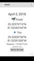
170 meters off
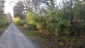
The gravel road

The convenience store
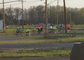
A group of local cyclists


