Difference between revisions of "2018-04-14 49 19"
imported>Malgond |
imported>Malgond (→Expedition) |
||
| Line 28: | Line 28: | ||
Sadly, this expedition was marked by failures and disappointments. Nevertheless, no failure prevents a dedicated geohasher from having a nice adventure even if it turns out not quite like planned. | Sadly, this expedition was marked by failures and disappointments. Nevertheless, no failure prevents a dedicated geohasher from having a nice adventure even if it turns out not quite like planned. | ||
| − | Since it was Saturday, I originally planned to arrive there by hash o'clock to boost my pathetic centurion achievement just a little bit. I intended to set out at 2 p.m. to get there before 4 p.m. - but you know how it goes with kids. In the end we set out at a quarter to four. Our planned route led us south along the dual-carriage road towards [[wikipedia:Zakopane|Zakopane]], then west along route 52 towards [[wikipedia:Bielsko-Biała|Bielsko-Biała]], the "capital" of the graticule. We've passed the towns of [[wikipedia:Kalwaria Zebrzydowska|Kalwaria Zebrzydowska]], [[wikipedia:Wadowice|Wadowice]] and [[wikipedia:Andrychów|Andrychów]] and turned south towards [[wikipedia:Porąbka, Silesian Voivodeship|Porąbka]] and [[wikipedia:Międzybrodzie Bialskie|Międzybrodzie Bialskie]], our destination. | + | Since it was Saturday, I originally planned to arrive there by hash o'clock to boost my pathetic centurion achievement just a little bit. I intended to set out at 2 p.m. to get there before 4 p.m. - but you know how it goes with kids. In the end we set out at a quarter to four. The weather was wonfderful - sunny with a clear light-blue early-spring sky. Our planned route led us south along the dual-carriage road towards [[wikipedia:Zakopane|Zakopane]], then west along route 52 towards [[wikipedia:Bielsko-Biała|Bielsko-Biała]], the "capital" of the graticule. We've passed the towns of [[wikipedia:Kalwaria Zebrzydowska|Kalwaria Zebrzydowska]], [[wikipedia:Wadowice|Wadowice]] and [[wikipedia:Andrychów|Andrychów]] and turned south towards [[wikipedia:Porąbka, Silesian Voivodeship|Porąbka]] and [[wikipedia:Międzybrodzie Bialskie|Międzybrodzie Bialskie]], our destination. |
<gallery perrow="5"> | <gallery perrow="5"> | ||
| Line 52: | Line 52: | ||
Image:2018-04-14_49-19_15.jpeg | A closed gate. | Image:2018-04-14_49-19_15.jpeg | A closed gate. | ||
</gallery> | </gallery> | ||
| + | |||
| + | I had to officially declare a failure. But it wasn't the end of the expedition! I would not be myself if I hadn't a backup plan. The has was located in a really picturesque and interesting area. A nice artificial lake surrounded by high mountains, one of which houses in its bowels the second largest hydroelectric plant in Poland - 500 megawatts of power from a water flowing down inside a mountain. The water, that had been pumped up to the top by the same plant. | ||
| + | |||
| + | <gallery perrow="5"> | ||
| + | Image:2018-04-14_49-19_16.jpeg | The power plant can be seen on the other shore. | ||
| + | Image:2018-04-14_49-19_17.jpeg | Pylons on the mountainside. | ||
| + | Image:2018-04-14_49-19_18.jpeg | Pylons close-up. | ||
| + | </gallery> | ||
| + | |||
| + | === The Żar Mountain === | ||
[[Category:Poland]] | [[Category:Poland]] | ||
Revision as of 19:36, 19 April 2018
| Sat 14 Apr 2018 in 49,19: 49.7832175, 19.1991100 geohashing.info google osm bing/os kml crox |
Location
A tavern(?) at Międzybrodzkie Lake.

According to Google Maps, today's coordinates fall in the grassy yard of a private-owned guesthouse/tavern/mooring at the shore of Międzybrodzkie Lake within the limits of Międzybrodzie Bialskie village. It looks like a nice place.
Participants
- Malgond
- his family.
Plans
Go there by car, have a nice afternoon at the lake and maybe a snack at the tavern (if it turns out any good).
Expedition
Sadly, this expedition was marked by failures and disappointments. Nevertheless, no failure prevents a dedicated geohasher from having a nice adventure even if it turns out not quite like planned.
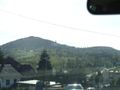
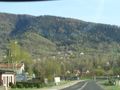
Since it was Saturday, I originally planned to arrive there by hash o'clock to boost my pathetic centurion achievement just a little bit. I intended to set out at 2 p.m. to get there before 4 p.m. - but you know how it goes with kids. In the end we set out at a quarter to four. The weather was wonfderful - sunny with a clear light-blue early-spring sky. Our planned route led us south along the dual-carriage road towards Zakopane, then west along route 52 towards Bielsko-Biała, the "capital" of the graticule. We've passed the towns of Kalwaria Zebrzydowska, Wadowice and Andrychów and turned south towards Porąbka and Międzybrodzie Bialskie, our destination.
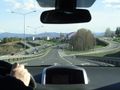
On the route 7 near Mogilany.
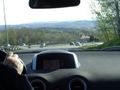
The road through the hills.
Approaching Kalwaria Zebrzydowska. Bernardines Monastery on the hill.
The hills turned into mountains.
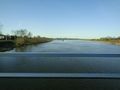
Crossing Soła river on a narrow one-lane bridge.
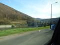
The dam of the Międzybrodzkie Lake.
The dam close-up.
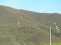
High-voltage pylons on the side of the Żar Mountain...
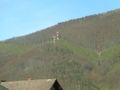
...leading to the pumped-storage hydroelectric plant.
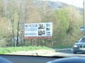
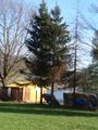
Our destination.


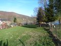
I have turned on a narrow driveway of the guesthouse and a parked on a lawn before the gate. Unfortunately, the venue was closed. Nobody responded to the doorbell. The grassy space and the tree under which the hashpoint was located was clearly visible, but unaccessible. At first I though we may be able to get close enough by going along the fence, but the neighbouring lot was guarded by a yellow gate with a 'no tresspassing sign'.
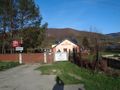
The guesthouse and tavern are closed.
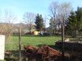
The grassy courtyard with the hashpoint.
The hashtree.
A fence along the yard.
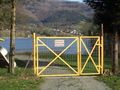
A closed gate.


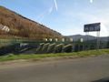
I had to officially declare a failure. But it wasn't the end of the expedition! I would not be myself if I hadn't a backup plan. The has was located in a really picturesque and interesting area. A nice artificial lake surrounded by high mountains, one of which houses in its bowels the second largest hydroelectric plant in Poland - 500 megawatts of power from a water flowing down inside a mountain. The water, that had been pumped up to the top by the same plant.
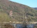
The power plant can be seen on the other shore.
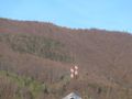
Pylons on the mountainside.
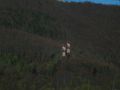
Pylons close-up.


