Difference between revisions of "2018-04-26 51 5"
From Geohashing
imported>Trevil (Created page with " <!-- If you did not specify these parameters in the template, please substitute appropriate values for IMAGE, LAT, LON, and DATE (YYYY-MM-DD format) Image:{{{image|IMAGE}...") |
imported>Trevil |
||
| Line 25: | Line 25: | ||
== Plans == | == Plans == | ||
| − | This hash coordinate is about 2 km from my home, I've got to try! I'll go there | + | This hash coordinate is about 2 km from my home, I've got to try! I'll go there somewhere between 16:00 and 17:00 (GMT+1). |
| + | |||
| − | |||
== Expedition == | == Expedition == | ||
| − | + | The hash coordinates landed about 2 km from my home, an opportunity one cannot let go. The coordinates seem to be in a grassy patch next to the road without mutch use. I took my bike and soon had a nice view of the coordinates. Unfortunately, the grass was a meadow with a few horses and some barbed wire stoped me in my quest. I briefly considered to switch from bike to horse but decided against it. | |
| + | <!-- | ||
== Tracklog == | == Tracklog == | ||
--> | --> | ||
| Line 39: | Line 40: | ||
Image:2012-##-## ## ## Alpha.jpg | Witty Comment | Image:2012-##-## ## ## Alpha.jpg | Witty Comment | ||
--> | --> | ||
| − | + | ||
<gallery perrow="5"> | <gallery perrow="5"> | ||
| − | Image: | + | Image:20180426_200+m_to_go.jpg | 214 m still to go |
| + | Image:20180426_vieuw_of_hash_and_horses.jpg | a meadow blocking my way | ||
| + | </gallery> | ||
| + | |||
| − | |||
| − | |||
<!-- | <!-- | ||
== Achievements == | == Achievements == | ||
| Line 61: | Line 63: | ||
<!-- =============== USEFUL CATEGORIES FOLLOW ================ | <!-- =============== USEFUL CATEGORIES FOLLOW ================ | ||
Delete the next line ONLY if you have chosen the appropriate categories below. If you are unsure, don't worry. People will read your report and help you with the classification. --> | Delete the next line ONLY if you have chosen the appropriate categories below. If you are unsure, don't worry. People will read your report and help you with the classification. --> | ||
| − | [[Category:New report]] | + | <!-- [[Category:New report]] --> |
| + | |||
| + | [[Category:Not reached - No public access]] | ||
| + | [[Category:Expeditions with photos]] | ||
<!-- ==REQUEST FOR TWITTER BOT== Please leave either the New report or the Expedition planning category in as long as you work on it. This helps the twitter bot a lot with announcing the right outcome at the right moment. --> | <!-- ==REQUEST FOR TWITTER BOT== Please leave either the New report or the Expedition planning category in as long as you work on it. This helps the twitter bot a lot with announcing the right outcome at the right moment. --> | ||
| Line 67: | Line 72: | ||
<!-- Potential categories. Please include all the ones appropriate to your expedition --> | <!-- Potential categories. Please include all the ones appropriate to your expedition --> | ||
<!-- If this is a planning page: --> | <!-- If this is a planning page: --> | ||
| − | [[Category:Expedition planning]] | + | <!-- [[Category:Expedition planning]] --> |
<!-- If all those plans are never acted upon, change [[Category:Expedition planning]] to [[Category:Not reached - Did not attempt]]. --> | <!-- If all those plans are never acted upon, change [[Category:Expedition planning]] to [[Category:Not reached - Did not attempt]]. --> | ||
Revision as of 17:15, 27 April 2018
| Thu 26 Apr 2018 in 51,5: 51.6906385, 5.2578988 geohashing.info google osm bing/os kml crox |
Location
In a field near the hospital of 's Hertogenbosch.
Participants
Plans
This hash coordinate is about 2 km from my home, I've got to try! I'll go there somewhere between 16:00 and 17:00 (GMT+1).
Expedition
The hash coordinates landed about 2 km from my home, an opportunity one cannot let go. The coordinates seem to be in a grassy patch next to the road without mutch use. I took my bike and soon had a nice view of the coordinates. Unfortunately, the grass was a meadow with a few horses and some barbed wire stoped me in my quest. I briefly considered to switch from bike to horse but decided against it.
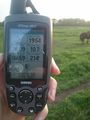
214 m still to go
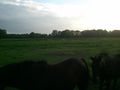
a meadow blocking my way

