Difference between revisions of "2018-06-01 -35 148"
From Geohashing
imported>1PE (Replaced content with "{{subst:Expedition |lat = -35 |lon = 150 |date = 2018-06-01}}") |
imported>1PE |
||
| Line 11: | Line 11: | ||
{{meetup graticule | {{meetup graticule | ||
| lat=-35 | | lat=-35 | ||
| − | | lon= | + | | lon=148 |
| date=2018-06-01 | | date=2018-06-01 | ||
}} | }} | ||
| Line 19: | Line 19: | ||
== Location == | == Location == | ||
| − | + | On the side of a road internal to a farm named "Parkwood" just west of the suburbs of my city. | |
== Participants == | == Participants == | ||
| + | ===[[User:1PE|1PE]]=== | ||
<!-- who attended: If you link to your wiki user name in this section, your expedition will be picked up by the various statistics generated for geohashing. You may use three tildes ~ as a shortcut to automatically insert the user signature of the account you are editing with. | <!-- who attended: If you link to your wiki user name in this section, your expedition will be picked up by the various statistics generated for geohashing. You may use three tildes ~ as a shortcut to automatically insert the user signature of the account you are editing with. | ||
--> | --> | ||
== Plans == | == Plans == | ||
| + | ===[[User:1PE|1]]PE]]=== | ||
| + | Go past around sunset (southern hemisphere Winter) about 5pm, on my way home from work. | ||
<!-- what were the original plans --> | <!-- what were the original plans --> | ||
== Expedition == | == Expedition == | ||
| + | ===[[User:1PE|1PE]]=== | ||
| + | I went to the road past the farm, just over the graticule border to the west, and there was a very prominent sign forbidding trespass on the property. I stopped at the gate and took some pictures; also at the road; then, also at the site of a former egg farm with the same name. | ||
<!-- how it all turned out. your narrative goes here. --> | <!-- how it all turned out. your narrative goes here. --> | ||
| Line 39: | Line 44: | ||
--> | --> | ||
<gallery perrow="5"> | <gallery perrow="5"> | ||
| + | Image:2018-06-01_-35_148_selfie.JPG|Beside the farm gate, trespass sign behind. The hash is about 1km in, above the top point of the map. | ||
| + | Image:2018-06-01_-35_148_road.JPG|Road signs to the farms, noting Parkwood. | ||
| + | Image:2018-06-01_-35_148_eggs.JPG|Returning along the road, here is the former "battery hen" farm adjoining. | ||
</gallery> | </gallery> | ||
| Line 58: | Line 66: | ||
<!-- If all those plans are never acted upon, change [[Category:Expedition planning]] to [[Category:Not reached - Did not attempt]]. --> | <!-- If all those plans are never acted upon, change [[Category:Expedition planning]] to [[Category:Not reached - Did not attempt]]. --> | ||
| + | [[Category:Expeditions]] | ||
| + | [[Category:Expeditions with photos]] | ||
| + | [[Category:Not reached - No public access]] | ||
<!-- An actual expedition: | <!-- An actual expedition: | ||
[[Category:Expeditions]] | [[Category:Expeditions]] | ||
Revision as of 16:13, 2 June 2018
| Fri 1 Jun 2018 in -35,148: -35.1982925, 148.9794792 geohashing.info google osm bing/os kml crox |
Location
On the side of a road internal to a farm named "Parkwood" just west of the suburbs of my city.
Participants
1PE
Plans
1PE]]
Go past around sunset (southern hemisphere Winter) about 5pm, on my way home from work.
Expedition
1PE
I went to the road past the farm, just over the graticule border to the west, and there was a very prominent sign forbidding trespass on the property. I stopped at the gate and took some pictures; also at the road; then, also at the site of a former egg farm with the same name.
Tracklog
Photos
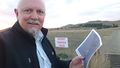
Beside the farm gate, trespass sign behind. The hash is about 1km in, above the top point of the map.
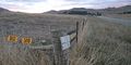
Road signs to the farms, noting Parkwood.
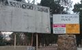
Returning along the road, here is the former "battery hen" farm adjoining.


Achievements