Difference between revisions of "2018-06-24 44 -96"
From Geohashing
imported>Fippe (Assuming the sign in Image:2018-06-24_44_-96_manicgecko_1529869493367.jpg is the problem and not the grass - no public access) |
m |
||
| (One intermediate revision by one other user not shown) | |||
| Line 24: | Line 24: | ||
<!-- who attended: If you link to your wiki user name in this section, your expedition will be picked up by the various statistics generated for geohashing. You may use three tildes ~ as a shortcut to automatically insert the user signature of the account you are editing with. | <!-- who attended: If you link to your wiki user name in this section, your expedition will be picked up by the various statistics generated for geohashing. You may use three tildes ~ as a shortcut to automatically insert the user signature of the account you are editing with. | ||
--> | --> | ||
| + | *[[User:manicgecko|manicgecko]] | ||
== Plans == | == Plans == | ||
| Line 51: | Line 52: | ||
[[Category:Coordinates not reached]] | [[Category:Coordinates not reached]] | ||
[[Category:Not reached - No public access]] | [[Category:Not reached - No public access]] | ||
| + | {{location|US|SD|BK}} | ||
Latest revision as of 13:16, 18 March 2022
| Sun 24 Jun 2018 in 44,-96: 44.4499918, -96.5216346 geohashing.info google osm bing/os kml crox |
Location
Participants
Plans
Expedition
Tracklog
Photos
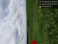
As close as I am going to get. Amazing views on the divide @44.4561,-96.5279
