Difference between revisions of "2018-08-11 51 -0"
From Geohashing
imported>TheOtterslider (→Plans) |
imported>TheOtterslider (→Photos) |
||
| Line 42: | Line 42: | ||
Image:2012-##-## ## ## Alpha.jpg | Witty Comment | Image:2012-##-## ## ## Alpha.jpg | Witty Comment | ||
--> | --> | ||
| − | <gallery perrow=" | + | <gallery perrow="3"> |
| + | Image:2018-08-11_51_-0_Attendees_web.jpg | Attendees / TheOtterslider and Saxbophone | ||
| + | Image:2018-08-11_51_-0_PointingAtActualLocation_web.jpg | Actual Location | ||
| + | Image:2018-08-11_51_-0_Proof.png | Proof | ||
| + | Image:2018-08-11_51_-0_N_web.jpg | North | ||
| + | Image:2018-08-11_51_-0_S_web.jpg | South | ||
| + | Image:2018-08-11_51_-0_E_web.jpg | East | ||
| + | Image:2018-08-11_51_-0_W_web.jpg | West | ||
</gallery> | </gallery> | ||
Revision as of 18:28, 11 August 2018
| Sat 11 Aug 2018 in 51,-0: 51.3385797, -0.3616675 geohashing.info google osm bing/os kml crox |
Location
Oxshott Heath, Surrey, England, UK.
This location is Common Land —this means the public can freely roam within it, whether on the path or off, so the hash should definitely be accessible (yipee)!
Participants
Plans
- Saxbophone (talk) plans to get the train out here from London, to arrive at 15:45. Oxshott Railway station is absurdly close to the hash, so 15 minutes should be more than enough time to make the 16:00 Saturday Meetup time.
- TheOtterslider (talk) is also planning to attend. It looks like there's a car park absurdly close
Expedition
Tracklog
Photos

Attendees / TheOtterslider and Saxbophone

Actual Location

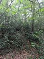
Proof
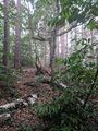
North
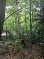
South
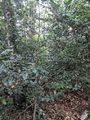
East
West


Achievements