Difference between revisions of "2018-08-24 51 9"
imported>Digiphono (→Tracklog) |
imported>Digiphono (→Expedition) |
||
| Line 33: | Line 33: | ||
== Expedition == | == Expedition == | ||
<!-- how it all turned out. your narrative goes here. --> | <!-- how it all turned out. your narrative goes here. --> | ||
| + | On fridays, I normally work only 6 hours and so I started my weekend at noon. Since the hash wasn't that far away from where I work, I decided to drive there and give it a try. The map showed a meadow along a small foresty area, and I didn't know what to expect. Was it a cornfield, or a meadow for cattle? Let's just go there and find out... | ||
| + | |||
| + | After I drove through the small village of Asmushausen, there was this asphalt road which I was allowed to drive on, which led me almost to the coordinates. Seemed to be getting an easy one! My mobile phone told me that I was only 130 meters away from the hashpoint, and after 300 meter by feet, I reached a ditch - and I saw this cattle fence on the other side, and thought that it wouldn't be possible to reach, because it were still 20 meters or so. After I got down into the ditch and climbed up on the other side, I noticed that my geohash droid app showed this nice message in green - "you're there"! | ||
| + | |||
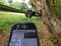
| + | I tried to get as accurate as possible, but having about 8 meters right at the cattle fence was good enough for me - no need to go under the fence to do another few meters, why? So I took some pictures and, since this was an extremely short hike (would have taken me 600 meters in total), I decided to go for two older geocaches (2007/2009) to achieve five kilometers at least. | ||
== Tracklog == | == Tracklog == | ||
Revision as of 15:18, 24 August 2018
| Fri 24 Aug 2018 in 51,9: 51.0154611, 9.8028336 geohashing.info google osm bing/os kml crox |
Location
On a pasture near Asmushausen / Bebra.
Participants
Plans
I want to visit this geohash right after my early shift at work.
Expedition
On fridays, I normally work only 6 hours and so I started my weekend at noon. Since the hash wasn't that far away from where I work, I decided to drive there and give it a try. The map showed a meadow along a small foresty area, and I didn't know what to expect. Was it a cornfield, or a meadow for cattle? Let's just go there and find out...
After I drove through the small village of Asmushausen, there was this asphalt road which I was allowed to drive on, which led me almost to the coordinates. Seemed to be getting an easy one! My mobile phone told me that I was only 130 meters away from the hashpoint, and after 300 meter by feet, I reached a ditch - and I saw this cattle fence on the other side, and thought that it wouldn't be possible to reach, because it were still 20 meters or so. After I got down into the ditch and climbed up on the other side, I noticed that my geohash droid app showed this nice message in green - "you're there"!
I tried to get as accurate as possible, but having about 8 meters right at the cattle fence was good enough for me - no need to go under the fence to do another few meters, why? So I took some pictures and, since this was an extremely short hike (would have taken me 600 meters in total), I decided to go for two older geocaches (2007/2009) to achieve five kilometers at least.
Tracklog
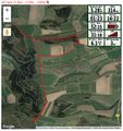
Todays track

Photos
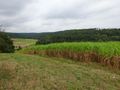
The way to the hash
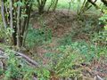
The hash is behind the cattle fence on the other side of the ditch
The hash - didn't need to get under that cattle fence
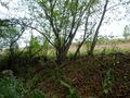
The hash - some meters behind that tree
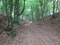
The way after the hash, into a tiny but nice forest
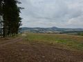
The panoramic view on my way back

The geohasher - to introduce me here


Achievements