Difference between revisions of "2018-09-02 52 4"
imported>FelixTheCat (Created page with "{{subst:Expedition |lat = 52 |lon = 4 |date = 2018-09-02 }}") |
imported>FelixTheCat |
||
| Line 1: | Line 1: | ||
| − | |||
| − | |||
| − | |||
| − | |||
| − | |||
| − | |||
| − | |||
| − | |||
| − | |||
| − | |||
{{meetup graticule | {{meetup graticule | ||
| lat=52 | | lat=52 | ||
| Line 14: | Line 4: | ||
| date=2018-09-02 | | date=2018-09-02 | ||
}} | }} | ||
| − | |||
| − | |||
__NOTOC__ | __NOTOC__ | ||
| − | |||
== Location == | == Location == | ||
| − | + | In the dunes near Katwijk. | |
== Participants == | == Participants == | ||
| − | + | [[User:FelixTheCat|FelixTheCat]] ([[User talk:FelixTheCat|talk]]) | |
| − | |||
| − | == | + | == Expedition == |
| − | + | It's a nice sunny Sunday. I have an appointment near(ish) Katwijk. And there's a geohash in the dunes. What's not to like? | |
| − | + | The hash was in a dune area. Sand dunes are the natural barriers that separate the sea from the land. They are also often critical components of the water supply. And finally, they are nature reserves with a fragile landscape containing several rare species of plants and animals. Therefore, although they're mostly publically accessible, you're supposed to remain on the marked trails at all times. Now it was not exactly clear how far off the track today's hash would be, so I was already prepared to be disappointed. | |
| − | + | ||
| + | However, when I arrived in the area, I found a sign explaining that, for a limited time only, it was allowed to leave the footpaths for the sole purpose of picking blackberries. Of course, this being the Netherlands, there was a huge string of rules attached (non-commercial use only, don't wander off elsewhere, no dogs allowed, etc etc), but I was feeling hopeful that this would provide me with legal access to the hash! Just look for a blackberry bush nearby and all would be fine. | ||
| − | + | I walked about 2 km through a pretty landscape. About 150 from the hash I ran into several large pieces of concrete and a wall stretching across the landscape. These are the remains of the [https://en.wikipedia.org/wiki/Atlantic_Wall Atlantic Wall], a long series of fortifications built to repel an Allied attack during World War II. A bit further on I ran into a more modern barrier: a locked fence with a "no entry" sign. With the hash only 121 metres away, it was clear that it was within a non-accessible area. I took a few pictures, explored the old fortifications a bit more, and then walked back to the hashmobile. | |
| − | |||
== Photos == | == Photos == | ||
| − | |||
| − | |||
| − | |||
<gallery perrow="5"> | <gallery perrow="5"> | ||
| + | Image:2018-09-02 52 4 FelixTheCat 1.JPG | The entrance to the dunes. | ||
| + | Image:2018-09-02 52 4 FelixTheCat 2.JPG | You're free to pick blackberries anywhere! | ||
| + | Image:2018-09-02 52 4 FelixTheCat 3.JPG | It's a nice place for a walk. | ||
| + | Image:2018-09-02 52 4 FelixTheCat 4.JPG | The remains of the Atlantic Wall. An actual wall on the left, tank traps across the water. | ||
| + | Image:2018-09-02 52 4 FelixTheCat 5.JPG | A fence on active duty! Built by the water supply company to protect its groundwater. | ||
| + | Image:2018-09-02 52 4 FelixTheCat 6.png | No luck this time... | ||
| + | Image:2018-09-02 52 4 FelixTheCat 7.JPG | Lloyd looking towards the hash. | ||
</gallery> | </gallery> | ||
== Achievements == | == Achievements == | ||
{{#vardefine:ribbonwidth|800px}} | {{#vardefine:ribbonwidth|800px}} | ||
| − | + | {{No trespassing | |
| − | + | | latitude = 52 | |
| − | + | | longitude = 4 | |
| − | + | | date = 2018-09-02 | |
| − | [[ | + | | name = [[User:FelixTheCat|FelixTheCat]] ([[User talk:FelixTheCat|talk]]) |
| − | + | | image = image name (optional) | |
| − | + | | distance = 121 m | |
| − | + | }} | |
| − | |||
| − | |||
| − | [[ | ||
| − | |||
| − | |||
| − | |||
| − | |||
| − | |||
[[Category:Expeditions]] | [[Category:Expeditions]] | ||
| − | |||
[[Category:Expeditions with photos]] | [[Category:Expeditions with photos]] | ||
| − | |||
| − | |||
| − | |||
| − | |||
| − | |||
| − | |||
| − | |||
| − | |||
| − | |||
[[Category:Coordinates not reached]] | [[Category:Coordinates not reached]] | ||
| − | |||
| − | |||
| − | |||
| − | |||
| − | |||
[[Category:Not reached - No public access]] | [[Category:Not reached - No public access]] | ||
| − | |||
| − | |||
| − | |||
| − | |||
| − | |||
| − | |||
| − | |||
| − | |||
Revision as of 20:40, 6 September 2018
| Sun 2 Sep 2018 in 52,4: 52.1774901, 4.3805173 geohashing.info google osm bing/os kml crox |
Location
In the dunes near Katwijk.
Participants
Expedition
It's a nice sunny Sunday. I have an appointment near(ish) Katwijk. And there's a geohash in the dunes. What's not to like?
The hash was in a dune area. Sand dunes are the natural barriers that separate the sea from the land. They are also often critical components of the water supply. And finally, they are nature reserves with a fragile landscape containing several rare species of plants and animals. Therefore, although they're mostly publically accessible, you're supposed to remain on the marked trails at all times. Now it was not exactly clear how far off the track today's hash would be, so I was already prepared to be disappointed.
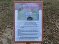
However, when I arrived in the area, I found a sign explaining that, for a limited time only, it was allowed to leave the footpaths for the sole purpose of picking blackberries. Of course, this being the Netherlands, there was a huge string of rules attached (non-commercial use only, don't wander off elsewhere, no dogs allowed, etc etc), but I was feeling hopeful that this would provide me with legal access to the hash! Just look for a blackberry bush nearby and all would be fine.
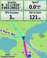
I walked about 2 km through a pretty landscape. About 150 from the hash I ran into several large pieces of concrete and a wall stretching across the landscape. These are the remains of the Atlantic Wall, a long series of fortifications built to repel an Allied attack during World War II. A bit further on I ran into a more modern barrier: a locked fence with a "no entry" sign. With the hash only 121 metres away, it was clear that it was within a non-accessible area. I took a few pictures, explored the old fortifications a bit more, and then walked back to the hashmobile.
Photos
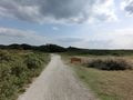
The entrance to the dunes.
You're free to pick blackberries anywhere!
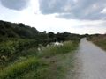
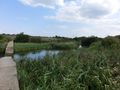
It's a nice place for a walk.
The remains of the Atlantic Wall. An actual wall on the left, tank traps across the water.
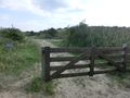
A fence on active duty! Built by the water supply company to protect its groundwater.
No luck this time...
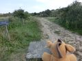
Lloyd looking towards the hash.


Achievements
FelixTheCat (talk) earned the No trespassing consolation prize
|