Difference between revisions of "2019-03-30 52 4"
imported>FelixTheCat (Created page with "{{subst:Expedition |lat = 52 |lon = 4 |date = 2019-03-30 }}") |
imported>FelixTheCat |
||
| Line 1: | Line 1: | ||
| − | |||
| − | |||
| − | |||
| − | |||
| − | |||
| − | |||
| − | |||
| − | |||
| − | |||
| − | |||
{{meetup graticule | {{meetup graticule | ||
| lat=52 | | lat=52 | ||
| Line 14: | Line 4: | ||
| date=2019-03-30 | | date=2019-03-30 | ||
}} | }} | ||
| − | |||
| − | |||
__NOTOC__ | __NOTOC__ | ||
== Location == | == Location == | ||
| − | + | Park Meijendel in The Hague. | |
== Participants == | == Participants == | ||
| − | + | [[User:FelixTheCat|FelixTheCat]] ([[User talk:FelixTheCat|talk]]) | |
| − | |||
| − | |||
| − | |||
| − | |||
== Expedition == | == Expedition == | ||
| − | + | Today's hash was in Meijendel, a large dune area on the northern end of The Hague. It was a beautiful spring day, so I got up early and rode my bike through Delft, Rijswijk, Voorburg and The Hague. Meijendel is a great place to walk or cycle, and I had been there many times before. I parked my bike at a bike stand and walked the last bit towards the hash. Unfortunately, there was a gate with a "no entry" sign about 180 metres from my target. Therefore, I got back on my bike and rode on, hoping to find a way to the other side that wasn't blocked. This didn't work, and it appeared the hash was really inside a no-go area. Still, I had a nice ride, and covered about 42 km in total. | |
| − | + | This expedition turned out to be very similar to my [[2018-09-02 52 4 | trip to Katwijk]] about six months ago. | |
| − | |||
| − | == Photos == | + | == Photos == |
| − | |||
| − | |||
| − | |||
<gallery perrow="5"> | <gallery perrow="5"> | ||
| + | Image:2019-03-30 52 4 FelixTheCat 1.JPG | Riding along the Vliet canal. | ||
| + | Image:2019-03-30 52 4 FelixTheCat 2.JPG | Turning left (over the little bridge) towards Rijswijk. | ||
| + | Image:2019-03-30 52 4 FelixTheCat 3.JPG | The intersection where Laan van Nieuw-Oosteinde (Voorburg) becomes Laan van Nieuw Oost Indië (The Hague). | ||
| + | Image:2019-03-30 52 4 FelixTheCat 4.JPG | The aforementioned street running through Haagse Bos (Forest of The Hague). | ||
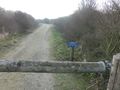
| + | Image:2019-03-30 52 4 FelixTheCat 5.JPG | Entering Meijendel. | ||
| + | Image:2019-03-30 52 4 FelixTheCat 6.JPG | The old water tower. Most of the area is owned by Dunea, the local water utility. | ||
| + | Image:2019-03-30 52 4 FelixTheCat 7.JPG | Parked the hash bike. | ||
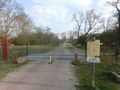
| + | Image:2019-03-30 52 4 FelixTheCat 8.JPG | Ran into this gate. No entry! | ||
| + | Image:2019-03-30 52 4 FelixTheCat 9.png | 181 metres from the hash. No prize this time. | ||
| + | Image:2019-03-30 52 4 FelixTheCat 10.JPG | Lloyd is disappointed. | ||
| + | Image:2019-03-30 52 4 FelixTheCat 11.JPG | The view from a lookout a bit further on. The hash is to the left of the lake in front. | ||
| + | Image:2019-03-30 52 4 FelixTheCat 12.JPG | A bit nearby is a WW2 tank barrier. | ||
</gallery> | </gallery> | ||
== Achievements == | == Achievements == | ||
{{#vardefine:ribbonwidth|800px}} | {{#vardefine:ribbonwidth|800px}} | ||
| − | + | {{No trespassing | |
| − | + | | latitude = 52 | |
| − | + | | longitude = 4 | |
| − | + | | date = 2019-03-30 | |
| − | [[ | + | | name = [[User:FelixTheCat|FelixTheCat]] ([[User talk:FelixTheCat|talk]]) |
| − | + | | image = 2019-03-30 52 4 FelixTheCat 8.JPG | |
| − | + | | distance = 181m | |
| − | + | }} | |
| − | |||
| − | |||
| − | [[ | ||
| − | -- | ||
| − | |||
| − | |||
| − | |||
| − | |||
[[Category:Expeditions]] | [[Category:Expeditions]] | ||
| − | |||
[[Category:Expeditions with photos]] | [[Category:Expeditions with photos]] | ||
| − | |||
| − | |||
| − | |||
| − | |||
| − | |||
| − | |||
| − | |||
| − | |||
| − | |||
| − | |||
| − | |||
[[Category:Coordinates not reached]] | [[Category:Coordinates not reached]] | ||
| − | |||
| − | |||
| − | |||
| − | |||
| − | |||
[[Category:Not reached - No public access]] | [[Category:Not reached - No public access]] | ||
| − | |||
| − | |||
| − | |||
| − | |||
| − | |||
| − | |||
| − | |||
| − | |||
Revision as of 13:05, 30 March 2019
| Sat 30 Mar 2019 in 52,4: 52.1235753, 4.3084305 geohashing.info google osm bing/os kml crox |
Location
Park Meijendel in The Hague.
Participants
Expedition
Today's hash was in Meijendel, a large dune area on the northern end of The Hague. It was a beautiful spring day, so I got up early and rode my bike through Delft, Rijswijk, Voorburg and The Hague. Meijendel is a great place to walk or cycle, and I had been there many times before. I parked my bike at a bike stand and walked the last bit towards the hash. Unfortunately, there was a gate with a "no entry" sign about 180 metres from my target. Therefore, I got back on my bike and rode on, hoping to find a way to the other side that wasn't blocked. This didn't work, and it appeared the hash was really inside a no-go area. Still, I had a nice ride, and covered about 42 km in total.
This expedition turned out to be very similar to my trip to Katwijk about six months ago.
Photos
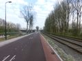
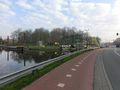
Riding along the Vliet canal.
Turning left (over the little bridge) towards Rijswijk.
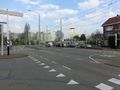
The intersection where Laan van Nieuw-Oosteinde (Voorburg) becomes Laan van Nieuw Oost Indië (The Hague).
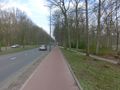
The aforementioned street running through Haagse Bos (Forest of The Hague).
Entering Meijendel.
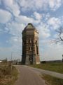
The old water tower. Most of the area is owned by Dunea, the local water utility.
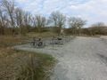
Parked the hash bike.
Ran into this gate. No entry!
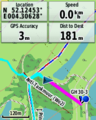
181 metres from the hash. No prize this time.
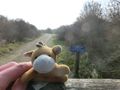
Lloyd is disappointed.
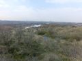
The view from a lookout a bit further on. The hash is to the left of the lake in front.
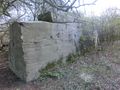
A bit nearby is a WW2 tank barrier.


Achievements
FelixTheCat (talk) earned the No trespassing consolation prize
|