Difference between revisions of "2019-05-04 62 29"
imported>Kripakko (Created page with "{{subst:Expedition |lat = 62 |lon = 29 |date = 2019-05-04 }}") |
m (Cleanup overall and hyperlink in Radio Yerevan box) |
||
| (8 intermediate revisions by 2 users not shown) | |||
| Line 1: | Line 1: | ||
| − | |||
| − | |||
| − | |||
| − | |||
| − | |||
| − | |||
| − | |||
| − | |||
| − | |||
| − | |||
{{meetup graticule | {{meetup graticule | ||
| lat=62 | | lat=62 | ||
| Line 15: | Line 5: | ||
}} | }} | ||
| − | |||
__NOTOC__ | __NOTOC__ | ||
== Location == | == Location == | ||
| − | + | On some house's backyard in Onttola, Kontiolahti. | |
== Participants == | == Participants == | ||
| − | + | * [[User:Kripakko|Kripakko]] | |
| − | |||
== Plans == | == Plans == | ||
| − | + | Judging by the topographic map and aerial photo by the National Land Survey of Finland [https://asiointi.maanmittauslaitos.fi/karttapaikka/?lang=en&share=customMarker&n=6949039.432&e=637050.100&title=Geohash+2019-05-04&desc=&zoom=13&layers=%5B%7B%22id%22%3A2%2C%22opacity%22%3A100%7D%2C%7B%22id%22%3A3%2C%22opacity%22%3A100%7D%5D] (''if you get only a white map then the application has glitched, so try again – it should work''), I can get within six metres of the hashpoint on public land. I will go and see how close I can get. If I am lucky, I might meet someone and get a permission to visit the actual point. | |
== Expedition == | == Expedition == | ||
| − | + | I grabbed my bicycle and started to cycle towards the hashpoint. When I started, it was already snowing, but soon it turned into a snowstorm with strong wind and snow falling horizontally. And of course, it winded right against my face. It did not keep me from cycling though, and eventually I reached Onttola and the vicinity of the hashpoint. | |
| + | |||
| + | ''Side note: Yes, I am serious about the snowstorm. It has been snowing here for one and a half days, and today it got quite windy, too. Here in Eastern Finland, we can have snowfall in any time of year from September to June.'' | ||
| + | |||
| + | As I had thought, I was able to get to about five-metre distance from the hashpoint. There was a high fir fence which I was unable to cross, and when I stood right by it, I could get a stable GPS distance of four metres and once, for a split-second, only three metres. I could see no one on the yard, so I could not ask for a permission to enter, and I was definitely not going to trespass. Even the front yard looked like no one was at home, so I was completely out of luck. Well, at least I got some outdoors cycling exercise. | ||
| − | + | Also, I thought that this was a perfect moment to try to get the [[Tron achievement]]. I could plan my route so that the trail of my bicycle would not collide with itself. I had a moment where I did not remember where the cycleway went and had to backtrack a little bit. I was able to do it without crossing the previous trail in both real life and the GPS trail, but with only a sub-metre margin. Since I did not actually reach the hashpoint, this does not really matter, but whatever. | |
| − | |||
== Photos == | == Photos == | ||
| − | < | + | <gallery perrow="4"> |
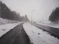
| − | Image: | + | Image:2019-05-04_62_29_01-road.jpg | Road to the hashpoint. |
| − | -- | + | Image:2019-05-04_62_29_02-gpsr.png | This is the closest that I could get to. |
| − | + | Image:2019-05-04_62_29_03-hashpoint1.jpg | Not possible to enter! | |
| + | Image:2019-05-04_62_29_04-hashpoint2.jpg | The road passing by the hashpoint. | ||
| + | Image:2019-05-04_62_29_05-farm.jpg | Some farm equipment, now covered with snow. | ||
| + | Image:2019-05-04_62_29_06-snowfall.jpg | The snowfall could even be captured by my camera. | ||
| + | Image:2019-05-04_62_29_07-map.png | My route plotted on a map. | ||
</gallery> | </gallery> | ||
== Achievements == | == Achievements == | ||
{{#vardefine:ribbonwidth|800px}} | {{#vardefine:ribbonwidth|800px}} | ||
| − | |||
| − | + | {{No trespassing | latitude = 62 | longitude = 29 | date = 2019-05-04 | name = Kripakko | distance = four metres!}} | |
| − | + | {{Radio Yerevan | achievement = [[Tron achievement]] | detail = he failed to reach the hashpoint | date = 2019-05-04 | latitude = 62 | longitude = 29 | user = Kripakko}} | |
| − | |||
| − | |||
| − | + | [[Category:Coordinates not reached]] | |
| − | + | [[Category:Not reached - No public access]] | |
| − | [[Category: | ||
| − | |||
| − | |||
| − | |||
| − | |||
| − | |||
[[Category:Expeditions]] | [[Category:Expeditions]] | ||
| − | |||
[[Category:Expeditions with photos]] | [[Category:Expeditions with photos]] | ||
| − | |||
| − | |||
| − | |||
| − | |||
| − | |||
| − | |||
| − | |||
| − | |||
| − | |||
| − | |||
| − | |||
| − | |||
| − | |||
| − | |||
| − | |||
| − | |||
| − | |||
| − | |||
| − | |||
| − | |||
| − | |||
| − | |||
| − | |||
| − | |||
| − | + | {{location|FI|13}} | |
Latest revision as of 22:00, 16 June 2022
| Sat 4 May 2019 in 62,29: 62.6464458, 29.6739706 geohashing.info google osm bing/os kml crox |
Location
On some house's backyard in Onttola, Kontiolahti.
Participants
Plans
Judging by the topographic map and aerial photo by the National Land Survey of Finland [1] (if you get only a white map then the application has glitched, so try again – it should work), I can get within six metres of the hashpoint on public land. I will go and see how close I can get. If I am lucky, I might meet someone and get a permission to visit the actual point.
Expedition
I grabbed my bicycle and started to cycle towards the hashpoint. When I started, it was already snowing, but soon it turned into a snowstorm with strong wind and snow falling horizontally. And of course, it winded right against my face. It did not keep me from cycling though, and eventually I reached Onttola and the vicinity of the hashpoint.
Side note: Yes, I am serious about the snowstorm. It has been snowing here for one and a half days, and today it got quite windy, too. Here in Eastern Finland, we can have snowfall in any time of year from September to June.
As I had thought, I was able to get to about five-metre distance from the hashpoint. There was a high fir fence which I was unable to cross, and when I stood right by it, I could get a stable GPS distance of four metres and once, for a split-second, only three metres. I could see no one on the yard, so I could not ask for a permission to enter, and I was definitely not going to trespass. Even the front yard looked like no one was at home, so I was completely out of luck. Well, at least I got some outdoors cycling exercise.
Also, I thought that this was a perfect moment to try to get the Tron achievement. I could plan my route so that the trail of my bicycle would not collide with itself. I had a moment where I did not remember where the cycleway went and had to backtrack a little bit. I was able to do it without crossing the previous trail in both real life and the GPS trail, but with only a sub-metre margin. Since I did not actually reach the hashpoint, this does not really matter, but whatever.
Photos
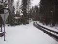
Road to the hashpoint.
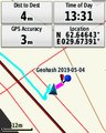
This is the closest that I could get to.
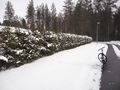
Not possible to enter!
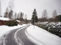
The road passing by the hashpoint.
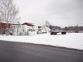
Some farm equipment, now covered with snow.
The snowfall could even be captured by my camera.

My route plotted on a map.


Achievements
Kripakko earned the No trespassing consolation prize
|
Is it true that Kripakko earned the Tron achievement?
|