Difference between revisions of "2019-05-20 54 -2"
From Geohashing
imported>Angel ([live picture]360° view from the hash. No infobox, because Geohash Droid mangles panoramas.) |
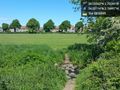
imported>Angel ([live picture]Hash reached! [http://www.openstreetmap.org/?lat=54.03060880&lon=-2.79241790&zoom=16&layers=B000FTF @54.0306,-2.7924]) |
||
| Line 45: | Line 45: | ||
Image:2019-05-20_54_-2_Angel_1558350569948.jpg|360° view from the hash. No infobox, because Geohash Droid mangles panoramas. | Image:2019-05-20_54_-2_Angel_1558350569948.jpg|360° view from the hash. No infobox, because Geohash Droid mangles panoramas. | ||
| + | |||
| + | Image:2019-05-20_54_-2_Angel_1558350641209.jpg|Hash reached! [http://www.openstreetmap.org/?lat=54.03060880&lon=-2.79241790&zoom=16&layers=B000FTF @54.0306,-2.7924] | ||
</gallery> | </gallery> | ||
Revision as of 11:10, 20 May 2019
| Mon 20 May 2019 in 54,-2: 54.0306206, -2.7924388 geohashing.info google osm bing/os kml crox |
Location
Participants
Plans
Expedition
- Looks like Barton Road playing fields; shouldbe easy enough to reach. -- Angel (talk) @54.0348,-2.7871 11:45, 20 May 2019 (GMT+01:00)
Tracklog
Photos
Nearly there :) @54.0311,-2.7900

360° view from the hash. No infobox, because Geohash Droid mangles panoramas.

Hash reached! @54.0306,-2.7924


Achievements