Difference between revisions of "2019-08-26 -37 145"
imported>Felix Dance ([live picture]Geohash fail [http://www.openstreetmap.org/?lat=-37.55946400&lon=145.16100660&zoom=16&layers=B000FTF @-37.5595,145.1610]) |
m |
||
| (5 intermediate revisions by 3 users not shown) | |||
| Line 1: | Line 1: | ||
| − | |||
| − | |||
| − | |||
| − | |||
| − | |||
| − | |||
| − | |||
| − | |||
| − | |||
| − | |||
{{meetup graticule | {{meetup graticule | ||
| lat=-37 | | lat=-37 | ||
| Line 14: | Line 4: | ||
| date=2019-08-26 | | date=2019-08-26 | ||
}} | }} | ||
| − | |||
| − | |||
| − | |||
== Location == | == Location == | ||
| − | + | Inside the Yan Yean Melbourne Water Catchment Area. | |
== Participants == | == Participants == | ||
| − | + | *[[User:Felix Dance|Felix Dance]] | |
| − | |||
| − | == | + | == Expedition == |
| − | + | I decided to spend Monday doing a long bike ride out north somewhere. Happily, there was a geohash not too far from my intended route. I took the train to Craigieburn and started heading east towards Yan Yean Reservoir. However, when I arrived along the unsealed road bordering the catchment area there was no public access - predictable, I guess, knowing Melbourne Water. | |
| + | |||
| + | I took some photos and continued my bike ride, which went around the reservoir, close to Whittlesea, up to Kinglake, down to Healesville, then up Mt Donna Buang, the latter of which really tried my road bike as it was a steep, gravel track up to the summit, partly submerged in snow. | ||
| − | + | After the sun set I flew down the mountain to Warburton then took the rail trail to Lilydale and the train home, arriving at about 9:30pm after 185kms. | |
| − | |||
| − | + | [https://goo.gl/maps/YUifskLHk64kh4Fk8 Here] is the route of my trip. | |
| − | |||
== Photos == | == Photos == | ||
| − | |||
| − | |||
| − | |||
<gallery perrow="5"> | <gallery perrow="5"> | ||
Image:2019-08-26_-37_145_Felix Dance_1566774789703.jpg|Geohash fail [http://www.openstreetmap.org/?lat=-37.55946400&lon=145.16100660&zoom=16&layers=B000FTF @-37.5595,145.1610] | Image:2019-08-26_-37_145_Felix Dance_1566774789703.jpg|Geohash fail [http://www.openstreetmap.org/?lat=-37.55946400&lon=145.16100660&zoom=16&layers=B000FTF @-37.5595,145.1610] | ||
| + | |||
| + | Image:2019-08-26_-37_145_Felix Dance_1566774806172.jpg|Prohibition sign | ||
</gallery> | </gallery> | ||
== Achievements == | == Achievements == | ||
| − | |||
| − | |||
| − | |||
| − | |||
| − | |||
| − | |||
| − | |||
| − | |||
| − | |||
| − | |||
| − | |||
| − | |||
| − | |||
| − | |||
| − | |||
| − | |||
[[Category:Expeditions]] | [[Category:Expeditions]] | ||
| − | |||
[[Category:Expeditions with photos]] | [[Category:Expeditions with photos]] | ||
| − | |||
| − | |||
| − | |||
| − | |||
| − | |||
| − | |||
| − | |||
| − | |||
| − | |||
[[Category:Coordinates not reached]] | [[Category:Coordinates not reached]] | ||
| − | |||
| − | |||
| − | |||
| − | |||
| − | |||
[[Category:Not reached - No public access]] | [[Category:Not reached - No public access]] | ||
| − | + | {{location|AU|VIC|WS}} | |
| − | |||
| − | |||
| − | |||
| − | |||
| − | |||
| − | |||
| − | |||
Latest revision as of 13:31, 23 September 2021
| Mon 26 Aug 2019 in -37,145: -37.5504559, 145.1490350 geohashing.info google osm bing/os kml crox |
Location
Inside the Yan Yean Melbourne Water Catchment Area.
Participants
Expedition
I decided to spend Monday doing a long bike ride out north somewhere. Happily, there was a geohash not too far from my intended route. I took the train to Craigieburn and started heading east towards Yan Yean Reservoir. However, when I arrived along the unsealed road bordering the catchment area there was no public access - predictable, I guess, knowing Melbourne Water.
I took some photos and continued my bike ride, which went around the reservoir, close to Whittlesea, up to Kinglake, down to Healesville, then up Mt Donna Buang, the latter of which really tried my road bike as it was a steep, gravel track up to the summit, partly submerged in snow.
After the sun set I flew down the mountain to Warburton then took the rail trail to Lilydale and the train home, arriving at about 9:30pm after 185kms.
Here is the route of my trip.
Photos
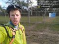
Geohash fail @-37.5595,145.1610
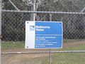
Prohibition sign

