Difference between revisions of "2020-01-23 52 4"
FelixTheCat (talk | contribs) (Created page with "{{subst:Expedition |lat = 52 |lon = 4 |date = 2020-01-23 }}") |
FelixTheCat (talk | contribs) |
||
| Line 1: | Line 1: | ||
| − | |||
| − | |||
| − | |||
| − | |||
| − | |||
| − | |||
| − | |||
| − | |||
| − | |||
| − | |||
{{meetup graticule | {{meetup graticule | ||
| lat=52 | | lat=52 | ||
| Line 14: | Line 4: | ||
| date=2020-01-23 | | date=2020-01-23 | ||
}} | }} | ||
| − | |||
| − | |||
__NOTOC__ | __NOTOC__ | ||
== Location == | == Location == | ||
| − | + | In a forest in Loosduinen, The Hague. | |
== Participants == | == Participants == | ||
| − | + | [[User:FelixTheCat|FelixTheCat]] ([[User talk:FelixTheCat|talk]]) | |
| − | |||
| − | |||
| − | |||
| − | |||
== Expedition == | == Expedition == | ||
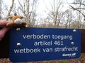
| − | + | Today's hash was in a forest near the beach of The Hague. I wasn't sure if it would be accessible, since neither Google Maps nor OpenStreetMap showed any paths leading towards it, and there were several buildings nearby which could mean that the forest was private property. Nevertheless, I wanted to give it a try, since it was within easy cycling distance. As I rode along the main road towards the hash, I suddenly saw an entrance into the forest, with a footpath leading directly towards the hash! Could this be my lucky day? I parked my bike and started walking. The hash was just 350 metres ahead, and we were going in the right direction. It started to look like we might pull this of, but alas! With just 26 metres to go we ran into a fence with a clear "no entry" sign on it. | |
| − | |||
| − | |||
| − | |||
== Photos == | == Photos == | ||
| − | |||
| − | |||
| − | |||
<gallery perrow="5"> | <gallery perrow="5"> | ||
| + | Image:2020-01-23 52 4 FelixTheCat 1.JPG | The entrance to the forest. | ||
| + | Image:2020-01-23 52 4 FelixTheCat 2.JPG | The path leading towards the hash. | ||
| + | Image:2020-01-23 52 4 FelixTheCat 3.JPG | The fence blocking our way. | ||
| + | Image:2020-01-23 52 4 FelixTheCat 4.png | Just 26 metres to go.... | ||
| + | Image:2020-01-23 52 4 FelixTheCat 5.JPG | Lloyd is disappointed. | ||
</gallery> | </gallery> | ||
== Achievements == | == Achievements == | ||
{{#vardefine:ribbonwidth|800px}} | {{#vardefine:ribbonwidth|800px}} | ||
| − | + | {{No trespassing | |
| − | + | | latitude = 52 | |
| − | + | | longitude = 4 | |
| − | + | | date = 2020-01-23 | |
| − | [[ | + | | name = [[User:FelixTheCat|FelixTheCat]] ([[User talk:FelixTheCat|talk]]) |
| − | + | | image = 2020-01-23 52 4 FelixTheCat 5.JPG | |
| − | + | | distance = 26m | |
| − | + | }} | |
| − | |||
| − | |||
| − | [[ | ||
| − | -- | ||
| − | |||
| − | |||
| − | |||
| − | |||
[[Category:Expeditions]] | [[Category:Expeditions]] | ||
| − | |||
[[Category:Expeditions with photos]] | [[Category:Expeditions with photos]] | ||
| − | |||
| − | |||
| − | |||
| − | |||
| − | |||
| − | |||
| − | |||
| − | |||
| − | |||
[[Category:Coordinates not reached]] | [[Category:Coordinates not reached]] | ||
| − | |||
| − | |||
| − | |||
| − | |||
| − | |||
[[Category:Not reached - No public access]] | [[Category:Not reached - No public access]] | ||
| − | |||
| − | |||
| − | |||
| − | |||
| − | |||
| − | |||
| − | |||
| − | |||
Revision as of 14:14, 4 February 2020
| Thu 23 Jan 2020 in 52,4: 52.0495523, 4.2092022 geohashing.info google osm bing/os kml crox |
Location
In a forest in Loosduinen, The Hague.
Participants
Expedition
Today's hash was in a forest near the beach of The Hague. I wasn't sure if it would be accessible, since neither Google Maps nor OpenStreetMap showed any paths leading towards it, and there were several buildings nearby which could mean that the forest was private property. Nevertheless, I wanted to give it a try, since it was within easy cycling distance. As I rode along the main road towards the hash, I suddenly saw an entrance into the forest, with a footpath leading directly towards the hash! Could this be my lucky day? I parked my bike and started walking. The hash was just 350 metres ahead, and we were going in the right direction. It started to look like we might pull this of, but alas! With just 26 metres to go we ran into a fence with a clear "no entry" sign on it.
Photos
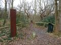
The entrance to the forest.
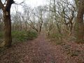
The path leading towards the hash.
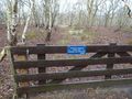
The fence blocking our way.
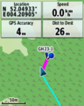
Just 26 metres to go....
Lloyd is disappointed.


Achievements
FelixTheCat (talk) earned the No trespassing consolation prize
|