Difference between revisions of "2020-01-25 48 11"
From Geohashing
Clearlucid9 (talk | contribs) |
Clearlucid9 (talk | contribs) (→Expedition) |
||
| Line 12: | Line 12: | ||
==Expedition== | ==Expedition== | ||
| − | The Geohashing website was still down, but as the app kept showing the coordinates I decided to go for this one on an early Saturday morning. As the area looked to be reasonable flat I took my new drone with me (thanks Santa Clause!) to take some areal shots. It was still quite chilly and as the drone connects to my phone I | + | The Geohashing website was still down, but as the app kept showing the coordinates I decided to go for this one on an early Saturday morning. As the area looked to be reasonable flat I took my new drone with me (thanks Santa Clause!) to take some areal shots. It was still quite chilly and as the drone connects to my phone I had to take of my gloves in order to use the app. After about 15 minutes I didn't feel my fingers any more and decided to drive back home and have breakfast. |
==Photos== | ==Photos== | ||
Revision as of 20:51, 20 February 2020
| Fri 4 Oct 2019 in Munich: 48.0569072, 11.7493048 geohashing.info google osm bing/os kml crox |
Contents
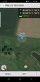
Location
on the fringe of the Harthausen golf course
Participants
Expedition
The Geohashing website was still down, but as the app kept showing the coordinates I decided to go for this one on an early Saturday morning. As the area looked to be reasonable flat I took my new drone with me (thanks Santa Clause!) to take some areal shots. It was still quite chilly and as the drone connects to my phone I had to take of my gloves in order to use the app. After about 15 minutes I didn't feel my fingers any more and decided to drive back home and have breakfast.
Photos
logproof

me at the hash
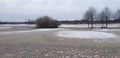
looking east
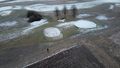
drone fiew of the area


