Difference between revisions of "2020-02-11 59 18"
From Geohashing
(report on expedition) |
|||
| (One intermediate revision by one other user not shown) | |||
| Line 1: | Line 1: | ||
| − | |||
| − | |||
| − | |||
| − | |||
| − | |||
| − | |||
| − | |||
| − | |||
| − | |||
| − | |||
{{meetup graticule | {{meetup graticule | ||
| lat=59 | | lat=59 | ||
| Line 14: | Line 4: | ||
| date=2020-02-11 | | date=2020-02-11 | ||
}} | }} | ||
| − | |||
| − | |||
__NOTOC__ | __NOTOC__ | ||
| Line 23: | Line 11: | ||
== Participants == | == Participants == | ||
[[User:Fractal|Fractal]] ([[User talk:Fractal|talk]]) | [[User:Fractal|Fractal]] ([[User talk:Fractal|talk]]) | ||
| − | |||
| − | |||
| − | |||
== Expedition == | == Expedition == | ||
| − | + | I left work at about 6pm and took a bus in direction of the hash. It then took me maybe five minutes to get as close as possible as I could get. It was at a crossing between two streets, but the hash itself was unfortunately inside a private building, as expected from Google Maps, and I didn’t attempt to get in. | |
| − | |||
| − | |||
| − | |||
== Photos == | == Photos == | ||
| − | < | + | <gallery widths=250px heights=250px> |
| − | Image: | + | Image:2020-02-11_59_18-1.jpg | The crossing (the hash is in the building on the right) |
| − | -- | + | Image:2020-02-11_59_18-2.jpg | Me as close as possible to the hash |
| − | + | Image:2020-02-11_59_18-3.png | "Proof" | |
</gallery> | </gallery> | ||
| − | |||
| − | |||
| − | |||
| − | |||
| − | |||
| − | |||
| − | |||
| − | |||
| − | |||
| − | |||
| − | |||
| − | |||
| − | |||
| − | |||
| − | |||
| − | |||
| − | |||
| − | |||
[[Category:Expeditions]] | [[Category:Expeditions]] | ||
| − | |||
[[Category:Expeditions with photos]] | [[Category:Expeditions with photos]] | ||
| − | |||
| − | |||
| − | |||
| − | |||
| − | |||
| − | |||
| − | |||
| − | |||
| − | |||
[[Category:Coordinates not reached]] | [[Category:Coordinates not reached]] | ||
| − | |||
| − | |||
| − | |||
| − | |||
| − | |||
[[Category:Not reached - No public access]] | [[Category:Not reached - No public access]] | ||
| − | |||
| − | |||
| − | |||
| − | |||
| − | |||
| − | |||
| − | |||
| − | |||
{{location|SE|AB}} | {{location|SE|AB}} | ||
Latest revision as of 11:07, 30 May 2020
| Tue 11 Feb 2020 in 59,18: 59.3368173, 18.0828671 geohashing.info google osm bing/os kml crox |
Location
The hash is located in central Stockholm (Östermalm), but unfortunately inside a building which does not seem public.
Participants
Expedition
I left work at about 6pm and took a bus in direction of the hash. It then took me maybe five minutes to get as close as possible as I could get. It was at a crossing between two streets, but the hash itself was unfortunately inside a private building, as expected from Google Maps, and I didn’t attempt to get in.
Photos
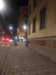
The crossing (the hash is in the building on the right)

Me as close as possible to the hash
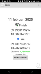
"Proof"


