Difference between revisions of "2020-03-28 39 -76"
From Geohashing
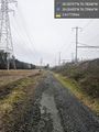
([live picture]Entrance to the final, difficult portion of the route [https://openstreetmap.org/?lat=39.05790280&lon=-76.78103480&zoom=16&layers=B000FTF @39.0579,-76.7810]) |
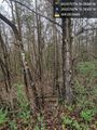
([live picture]I keep coming across these signs from the wrong direction! [https://openstreetmap.org/?lat=39.04279530&lon=-76.76265050&zoom=16&layers=B000FTF @39.0428,-76.7627]) |
||
| Line 46: | Line 46: | ||
Image:2020-03-28_39_-76_OfficeLinebacker_1585433114031.jpg|Entrance to the final, difficult portion of the route [https://openstreetmap.org/?lat=39.05790280&lon=-76.78103480&zoom=16&layers=B000FTF @39.0579,-76.7810] | Image:2020-03-28_39_-76_OfficeLinebacker_1585433114031.jpg|Entrance to the final, difficult portion of the route [https://openstreetmap.org/?lat=39.05790280&lon=-76.78103480&zoom=16&layers=B000FTF @39.0579,-76.7810] | ||
| + | |||
| + | Image:2020-03-28_39_-76_OfficeLinebacker_1585435736488.jpg|I keep coming across these signs from the wrong direction! [https://openstreetmap.org/?lat=39.04279530&lon=-76.76265050&zoom=16&layers=B000FTF @39.0428,-76.7627] | ||
</gallery> | </gallery> | ||
Revision as of 22:49, 28 March 2020
| Sat 28 Mar 2020 in 39,-76: 39.0579727, -76.7826840 geohashing.info google osm bing/os kml crox |
Location
Participants
Plans
Expedition
- Hope to go, but it might be raining -- OfficeLinebacker (talk) 20:50, 27 March 2020 (EDT)
- Hope to go tomorrow, but it looks like rain. -- OfficeLinebacker (talk) 20:52, 27 March 2020 (EDT)
- Definitely trying this -- OfficeLinebacker (talk) 14:46, 28 March 2020 (EDT)
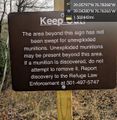
- At first, I thought that this was on the grounds of the Patuxent Wildlife Refuge. However upon arriving at the visitor center and seeing a map of the grounds, I see that the property here does not include the geohashing location -- OfficeLinebacker (talk) @39.0296,-76.8027 16:18, 28 March 2020 (EDT)
Tracklog
Photos
Found a relatively clear path to follow, even if it's not the most direct route. @39.0246,-76.7596
Entrance to the final, difficult portion of the route @39.0579,-76.7810
I keep coming across these signs from the wrong direction! @39.0428,-76.7627


Achievements