Difference between revisions of "2020-04-21 38 -78"
From Geohashing
([live picture]The off-road adventure starts here, with 2500 feet to go. [https://openstreetmap.org/?lat=38.90322380&lon=-78.48479170&zoom=16&layers=B000FTF @38.9032,-78.4848]) |
([live picture]Actually, saw this not very used Access road. Hoping that leads to the power lines [https://openstreetmap.org/?lat=38.90353410&lon=-78.48538340&zoom=16&layers=B000FTF @38.9035,-78.4854]) |
||
| Line 38: | Line 38: | ||
Image:2020-04-21_38_-78_OfficeLinebacker_1587503466204.jpg|The off-road adventure starts here, with 2500 feet to go. [https://openstreetmap.org/?lat=38.90322380&lon=-78.48479170&zoom=16&layers=B000FTF @38.9032,-78.4848] | Image:2020-04-21_38_-78_OfficeLinebacker_1587503466204.jpg|The off-road adventure starts here, with 2500 feet to go. [https://openstreetmap.org/?lat=38.90322380&lon=-78.48479170&zoom=16&layers=B000FTF @38.9032,-78.4848] | ||
| + | |||
| + | Image:2020-04-21_38_-78_OfficeLinebacker_1587503572764.jpg|Actually, saw this not very used Access road. Hoping that leads to the power lines [https://openstreetmap.org/?lat=38.90353410&lon=-78.48538340&zoom=16&layers=B000FTF @38.9035,-78.4854] | ||
</gallery> | </gallery> | ||
Revision as of 21:13, 21 April 2020
| Tue 21 Apr 2020 in 38,-78: 38.8963044, -78.4865920 geohashing.info google osm bing/os kml crox |
Location
Participants
Plans
Expedition
- I'm going for this one. My tactics to achieve the objective will be to go down the land clearing for the power lines and approach the objective from a Westerly direction -- OfficeLinebacker (talk) 14:49, 21 April 2020 (EDT)
Tracklog
Photos
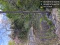
The off-road adventure starts here, with 2500 feet to go. @38.9032,-78.4848
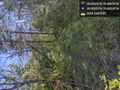
Actually, saw this not very used Access road. Hoping that leads to the power lines @38.9035,-78.4854


Achievements