Difference between revisions of "2020-04-30 47 -122"
From Geohashing
([live picture]geohasher [https://openstreetmap.org/?lat=47.73658690&lon=-122.21790070&zoom=16&layers=B000FTF @47.7366,-122.2179]) |
([live picture]location [https://openstreetmap.org/?lat=47.73659510&lon=-122.21787960&zoom=16&layers=B000FTF @47.7366,-122.2179]) |
||
| Line 44: | Line 44: | ||
Image:2020-04-30_47_-122_thomcat_1588270522924.jpg|geohasher [https://openstreetmap.org/?lat=47.73658690&lon=-122.21790070&zoom=16&layers=B000FTF @47.7366,-122.2179] | Image:2020-04-30_47_-122_thomcat_1588270522924.jpg|geohasher [https://openstreetmap.org/?lat=47.73658690&lon=-122.21790070&zoom=16&layers=B000FTF @47.7366,-122.2179] | ||
| + | |||
| + | Image:2020-04-30_47_-122_thomcat_1588270578829.jpg|location [https://openstreetmap.org/?lat=47.73659510&lon=-122.21787960&zoom=16&layers=B000FTF @47.7366,-122.2179] | ||
</gallery> | </gallery> | ||
Revision as of 18:16, 30 April 2020
| Thu 30 Apr 2020 in 47,-122: 47.7365681, -122.2179574 geohashing.info google osm bing/os kml crox |
Location
Participants
Plans
Expedition
- test -- Thomcat (talk) @47.7426,-122.2232 10:53, 30 April 2020 (PDT)
- test -- Thomcat (talk) @47.7426,-122.2232 10:54, 30 April 2020 (PDT)
Tracklog
Photos

En route - spring/summer workplace @47.7426,-122.2233
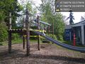
Closed playground @47.7367,-122.2187

geohasher @47.7366,-122.2179

location @47.7366,-122.2179


Achievements