2020-05-02 60 27
From Geohashing
Revision as of 13:40, 2 May 2020 by Artanicus (talk | contribs) ([live picture]Dry pine forest right next to the freeway. Surprisingly hard to find a route to but easy once you find the right bridge, visible in the background. [https://openstreetmap.org/?lat=60.61323650&lon=27.80852610&zoom=16&layers=B000FTF @60.613...)
| Sat 2 May 2020 in 60,27: 60.6131665, 27.8085498 geohashing.info google osm bing/os kml crox |
Location
Participants
Plans
Expedition
Tracklog
Photos
At the point @60.6132,27.8086
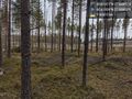
Dry pine forest right next to the freeway. Surprisingly hard to find a route to but easy once you find the right bridge, visible in the background. @60.6132,27.8085


Achievements