Difference between revisions of "2020-05-11 39 -77"
From Geohashing
([live picture]The off-piste excursion begins here [https://openstreetmap.org/?lat=39.93657290&lon=-77.43117560&zoom=16&layers=B000FTF @39.9366,-77.4312]) |
([live picture]I'm stopping here. The map was deceiving as far as looking like there was a road that would take me to within a couple hundred feet. This would require a 1-mile hiking dense underbrush [https://openstreetmap.org/?lat=39.93517580&lon=-77.4...) |
||
| Line 38: | Line 38: | ||
Image:2020-05-11_39_-77_OfficeLinebacker_1589236614355.jpg|The off-piste excursion begins here [https://openstreetmap.org/?lat=39.93657290&lon=-77.43117560&zoom=16&layers=B000FTF @39.9366,-77.4312] | Image:2020-05-11_39_-77_OfficeLinebacker_1589236614355.jpg|The off-piste excursion begins here [https://openstreetmap.org/?lat=39.93657290&lon=-77.43117560&zoom=16&layers=B000FTF @39.9366,-77.4312] | ||
| + | |||
| + | Image:2020-05-11_39_-77_OfficeLinebacker_1589237500175.jpg|I'm stopping here. The map was deceiving as far as looking like there was a road that would take me to within a couple hundred feet. This would require a 1-mile hiking dense underbrush [https://openstreetmap.org/?lat=39.93517580&lon=-77.42925150&zoom=16&layers=B000FTF @39.9352,-77.4293] | ||
</gallery> | </gallery> | ||
Revision as of 22:51, 11 May 2020
| Mon 11 May 2020 in 39,-77: 39.9296832, -77.4168584 geohashing.info google osm bing/os kml crox |
Location
Participants
Plans
Expedition
- This one appears to be deep in Pennsylvania Apple country and I'm going for it -- OfficeLinebacker (talk) @39.8742,-77.3675 18:02, 11 May 2020 (EDT)
Tracklog
Photos
The off-piste excursion begins here @39.9366,-77.4312

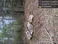
I'm stopping here. The map was deceiving as far as looking like there was a road that would take me to within a couple hundred feet. This would require a 1-mile hiking dense underbrush @39.9352,-77.4293


Achievements