Difference between revisions of "2020-05-13 39 -78"
From Geohashing
([live picture]It's 4100 feet up hill through Rocky terrain like this but I'm up for it today 💪 [https://openstreetmap.org/?lat=39.99615850&lon=-78.22126120&zoom=16&layers=B000FTF @39.9962,-78.2213]) |
([live picture]Unlike many of my previous adventures, I'm passing perpendicular to all of these nights pads. Three so far and counting [https://openstreetmap.org/?lat=39.99392090&lon=-78.21331850&zoom=16&layers=B000FTF @39.9939,-78.2133]) |
||
| Line 38: | Line 38: | ||
Image:2020-05-13_39_-78_OfficeLinebacker_1589407141652.jpg|It's 4100 feet up hill through Rocky terrain like this but I'm up for it today 💪 [https://openstreetmap.org/?lat=39.99615850&lon=-78.22126120&zoom=16&layers=B000FTF @39.9962,-78.2213] | Image:2020-05-13_39_-78_OfficeLinebacker_1589407141652.jpg|It's 4100 feet up hill through Rocky terrain like this but I'm up for it today 💪 [https://openstreetmap.org/?lat=39.99615850&lon=-78.22126120&zoom=16&layers=B000FTF @39.9962,-78.2213] | ||
| + | |||
| + | Image:2020-05-13_39_-78_OfficeLinebacker_1589409549996.jpg|Unlike many of my previous adventures, I'm passing perpendicular to all of these nights pads. Three so far and counting [https://openstreetmap.org/?lat=39.99392090&lon=-78.21331850&zoom=16&layers=B000FTF @39.9939,-78.2133] | ||
</gallery> | </gallery> | ||
Revision as of 22:39, 13 May 2020
| Wed 13 May 2020 in 39,-78: 39.9929843, -78.2072371 geohashing.info google osm bing/os kml crox |
Location
Participants
Plans
Expedition
- Going for this one today, which is near the infamous Breezewood Pennsylvania -- OfficeLinebacker (talk) @39.3248,-77.3544 15:58, 13 May 2020 (EDT)
Tracklog
Photos
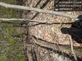
It's 4100 feet up hill through Rocky terrain like this but I'm up for it today 💪 @39.9962,-78.2213
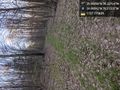
Unlike many of my previous adventures, I'm passing perpendicular to all of these nights pads. Three so far and counting @39.9939,-78.2133


Achievements