Difference between revisions of "2020-05-16 50 -3"
m |
(→Achievements) |
||
| (3 intermediate revisions by the same user not shown) | |||
| Line 20: | Line 20: | ||
== Expedition == | == Expedition == | ||
| − | Departed around 15. | + | Departed around 15.10 and cycled down to the Exe River. Continued cycling downstream between the river and the canal and spotted a train and manual bridge that would probably be fascinating when in use. |
| − | + | Crossed the river and continued on to the north end of the Exe Estuary before turning east in Topsham. Attacked by raptors on the outskirts of Topsham. Escaped with a small but quite painful wound likely received from a juvenile. | |
| + | |||
| + | Cycled along Woodbury Road to Woodbury, encountering butterfly (flitterbug) on the way. | ||
| + | Reached the farm the geohash was on at around 4.40, much later than originally intended. I was prevented from reaching the geohash as it was on private property. However, I was able to get within sight of the geohash by a path around a neighbouring field; the closest I could get was 120m. Attempted to get closer through another neighbouring field and was accosted by pheasant. Decided not to try my luck (field wasn't publicly accessible anyway). | ||
| + | |||
| + | Cycled home, retracing steps. Returned around 18.10. | ||
<!--== Tracklog ==--> | <!--== Tracklog ==--> | ||
| Line 31: | Line 36: | ||
--> | --> | ||
<gallery perrow="5"> | <gallery perrow="5"> | ||
| − | + | Image:2020-05-16 50 -3 Harowcal 01 geotrash.jpg|Geotrashing | |
| + | Image:2020-05-16 50 -3 Harowcal 02 train.jpg|Train! | ||
| + | Image:2020-05-16 50 -3 Harowcal 03 bridge.jpg|A fascinating manual bridge | ||
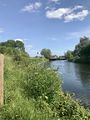
| + | Image:2020-05-16 50 -3 Harowcal 04 river.jpg|A view of the Exe, looking north | ||
| + | Image:2020-05-16 50 -3 Harowcal 05 raptor.jpg|Raptor wounds | ||
| + | Image:2020-05-16 50 -3 Harowcal 06 butterfly.jpg|A flitterbug | ||
| + | Image:2020-05-16 50 -3 Harowcal 07 estuary.jpg|The sea! Well, the estuary | ||
| + | Image:2020-05-16 50 -3 Harowcal 08 city.jpg|The city! Well, Topsham | ||
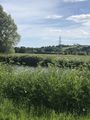
| + | Image:2020-05-16 50 -3 Harowcal 09 farm.jpg|The geohash farm; I'm not allowed in | ||
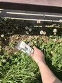
| + | Image:2020-05-16 50 -3 Harowcal 10 proof.jpg|Proof, as good as I can get | ||
| + | Image:2020-05-16 50 -3 Harowcal 11 map.jpg|This is how close I was | ||
| + | Image:2020-05-16 50 -3 Harowcal 12 geohash.jpg|The geohash, in there somewhere | ||
| + | Image:2020-05-16 50 -3 Harowcal 13 grin.jpg|Stupid grin<sup>TM</sup> | ||
| + | Image:2020-05-16 50 -3 Harowcal 14 pheasant.jpg|A common Devonshire pheasant | ||
</gallery> | </gallery> | ||
| Line 37: | Line 55: | ||
{{#vardefine:ribbonwidth|800px}} | {{#vardefine:ribbonwidth|800px}} | ||
<!-- Add any achievement ribbons you earned below, or remove this section --> | <!-- Add any achievement ribbons you earned below, or remove this section --> | ||
| − | {{No trespassing | latitude = 50 | longitude = -3 | date = 2020-05-16 | name = Harowcal | distance = 120m }} | + | {{No trespassing | latitude = 50 | longitude = -3 | date = 2020-05-16 | name = Harowcal | distance = 120m | image = 2020-05-16 50 -3 Harowcal 09 farm.jpg }} |
| + | [[Category:Expeditions]] | ||
| + | [[Category:Expeditions with photos]] | ||
[[Category:Coordinates not reached]] | [[Category:Coordinates not reached]] | ||
[[Category:Not reached - No public access]] | [[Category:Not reached - No public access]] | ||
{{location|GB|ENG|DEV}} | {{location|GB|ENG|DEV}} | ||
Latest revision as of 19:55, 17 May 2020
| Sat 16 May 2020 in 50,-3: 50.6817281, -3.4040167 geohashing.info google osm bing/os kml crox |
Location
On a farm just outside Woodbury.
Participants
Plans
This one and Sunday's are very close so I'll try to get to both of them at around 4pm. However, it looks like it isn't public access so I may not reach it.
Expedition
Departed around 15.10 and cycled down to the Exe River. Continued cycling downstream between the river and the canal and spotted a train and manual bridge that would probably be fascinating when in use.
Crossed the river and continued on to the north end of the Exe Estuary before turning east in Topsham. Attacked by raptors on the outskirts of Topsham. Escaped with a small but quite painful wound likely received from a juvenile.
Cycled along Woodbury Road to Woodbury, encountering butterfly (flitterbug) on the way. Reached the farm the geohash was on at around 4.40, much later than originally intended. I was prevented from reaching the geohash as it was on private property. However, I was able to get within sight of the geohash by a path around a neighbouring field; the closest I could get was 120m. Attempted to get closer through another neighbouring field and was accosted by pheasant. Decided not to try my luck (field wasn't publicly accessible anyway).
Cycled home, retracing steps. Returned around 18.10.
Photos
Geotrashing
Train!
A fascinating manual bridge
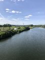
A view of the Exe, looking north
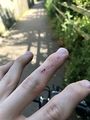
Raptor wounds
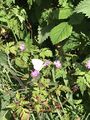
A flitterbug
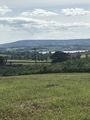
The sea! Well, the estuary
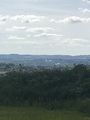
The city! Well, Topsham
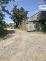
The geohash farm; I'm not allowed in
Proof, as good as I can get
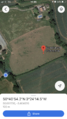
This is how close I was
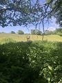
The geohash, in there somewhere
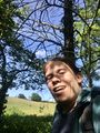
Stupid grinTM
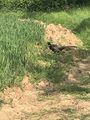
A common Devonshire pheasant


Achievements
Harowcal earned the No trespassing consolation prize
|