Difference between revisions of "2020-06-01 60 27"
From Geohashing
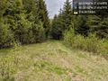
([live picture]At the point, the older side if the industrial forest [https://openstreetmap.org/?lat=60.51970710&lon=27.41699130&zoom=16&layers=B000FTF @60.5197,27.4170]) |
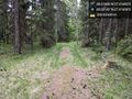
([live picture]At the point, the newer side of the industrial forest. Behind it s very tightly packed area of spruce. [https://openstreetmap.org/?lat=60.51973230&lon=27.41695970&zoom=16&layers=B000FTF @60.5197,27.4170]) |
||
| Line 44: | Line 44: | ||
Image:2020-06-01_60_27_Artanicus_1591014336826.jpg|At the point, the older side if the industrial forest [https://openstreetmap.org/?lat=60.51970710&lon=27.41699130&zoom=16&layers=B000FTF @60.5197,27.4170] | Image:2020-06-01_60_27_Artanicus_1591014336826.jpg|At the point, the older side if the industrial forest [https://openstreetmap.org/?lat=60.51970710&lon=27.41699130&zoom=16&layers=B000FTF @60.5197,27.4170] | ||
| + | |||
| + | Image:2020-06-01_60_27_Artanicus_1591014426717.jpg|At the point, the newer side of the industrial forest. Behind it s very tightly packed area of spruce. [https://openstreetmap.org/?lat=60.51973230&lon=27.41695970&zoom=16&layers=B000FTF @60.5197,27.4170] | ||
</gallery> | </gallery> | ||
Revision as of 12:27, 1 June 2020
| Mon 1 Jun 2020 in 60,27: 60.5196608, 27.4169487 geohashing.info google osm bing/os kml crox |
Location
Participants
Plans
Expedition
Tracklog
Photos
Surprisingly close by car @60.5216,27.4168
The road was quite small though @60.5216,27.4168
Rest of the way at first at least road-ish, but not drivable. @60.5214,27.4161
At the point @60.5196,27.4169
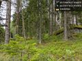
At the point, the older side if the industrial forest @60.5197,27.4170
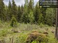
At the point, the newer side of the industrial forest. Behind it s very tightly packed area of spruce. @60.5197,27.4170


Achievements