Difference between revisions of "2020-06-29 50 -3"
(added expedition) |
|||
| Line 1: | Line 1: | ||
| − | + | [[Image:{{{image|2020-06-29 50 -3 Harowcal 12 plough.JPG}}}|thumb|left]] | |
{{meetup graticule | {{meetup graticule | ||
| Line 18: | Line 18: | ||
<!-- what were the original plans --> | <!-- what were the original plans --> | ||
== Expedition == | == Expedition == | ||
| − | + | Departed around 15.35 and cycled northwest out of Exeter, taking a brief diversion to avoid the steep part of the hill of Redhills. Encountered several birds, photographed one. Passed a path down into Barley Valley Nature Reserve that might have been worth exploring but didn't. | |
| + | |||
| + | Continued on to Nadderwater. At the top of Redhills thought I smelled a barbecue and/or bonfire. Expected to turn west to cross the Nadder Brook but never noticed it, instead following the road through the village and beyond. Later realised the small stream under the road was the waterway in question and felt somewhat underwhelmed. | ||
| + | |||
| + | Headed west to Whitestone. Along the way took a break to observe a pair of ambivalent horses (one pictured). Passed through Whitestone uneventfully. At some point along this stretched passed a pair of horse riders. The road from Whitestone to the geohash included several gates looking south, offering a wide view of the valley. One gate lead to Ramslade Farm, which had a rather artistic depiction of a common Devonshire pheasant on its sign. | ||
| + | |||
| + | Reached the geohash field, which was open. Stepped just inside the field before hearing angry barking and spotting a pair of dogs running up the path, and duly left. Took stupid grin photo from as near as I could get, along with visual on the geohash. Debated whether this counted as a successful expedition but later decided against it. | ||
| + | |||
| + | On passing back through Whitestone, noticed a plough that had been donated for ornamentation, presumably by the family of a local farmer. In Nadderwater discovered a plaque detailing the story of the Trafalgar Way, part of which I had followed for my expedition. Returned around 17.30. | ||
<!--== Tracklog ==--> | <!--== Tracklog ==--> | ||
<!-- if your GPS device keeps a log, you may post a link here --> | <!-- if your GPS device keeps a log, you may post a link here --> | ||
| − | |||
== Photos == | == Photos == | ||
<!-- Insert pictures between the gallery tags using the following format: | <!-- Insert pictures between the gallery tags using the following format: | ||
| Line 32: | Line 39: | ||
Image:2020-06-29 50 -3 Harowcal 03 east.JPG|Looking East (towards Exeter) | Image:2020-06-29 50 -3 Harowcal 03 east.JPG|Looking East (towards Exeter) | ||
Image:2020-06-29 50 -3 Harowcal 04 west.JPG|Looking West (towards the moor) | Image:2020-06-29 50 -3 Harowcal 04 west.JPG|Looking West (towards the moor) | ||
| − | Image:2020-06-29 50 -3 Harowcal 05 sign.JPG|A | + | Image:2020-06-29 50 -3 Harowcal 05 sign.JPG|A pheasant (artist's rendition) |
</gallery> | </gallery> | ||
<gallery perrow="1" widths="758px"> | <gallery perrow="1" widths="758px"> | ||
| Line 41: | Line 48: | ||
Image:2020-06-29 50 -3 Harowcal 08 geohash.JPG|The geohash, in there somewhere | Image:2020-06-29 50 -3 Harowcal 08 geohash.JPG|The geohash, in there somewhere | ||
Image:2020-06-29 50 -3 Harowcal 09 stupid grin.JPG|Stupid grin<sup>TM</sup> | Image:2020-06-29 50 -3 Harowcal 09 stupid grin.JPG|Stupid grin<sup>TM</sup> | ||
| − | |||
Image:2020-06-29 50 -3 Harowcal 11 town.JPG|Village of Whitestone | Image:2020-06-29 50 -3 Harowcal 11 town.JPG|Village of Whitestone | ||
Image:2020-06-29 50 -3 Harowcal 12 plough.JPG|Ornamental plough | Image:2020-06-29 50 -3 Harowcal 12 plough.JPG|Ornamental plough | ||
| Line 48: | Line 54: | ||
Image:2020-06-29 50 -3 Harowcal 15 river.JPG|The river through Nadderwater | Image:2020-06-29 50 -3 Harowcal 15 river.JPG|The river through Nadderwater | ||
Image:2020-06-29 50 -3 Harowcal 16 bridge.JPG|The bridge over the river | Image:2020-06-29 50 -3 Harowcal 16 bridge.JPG|The bridge over the river | ||
| + | Image:2020-06-29 50 -3 Harowcal 17 river.JPG|The other end of the river | ||
</gallery> | </gallery> | ||
| Line 53: | Line 60: | ||
{{#vardefine:ribbonwidth|800px}} | {{#vardefine:ribbonwidth|800px}} | ||
<!-- Add any achievement ribbons you earned below, or remove this section --> | <!-- Add any achievement ribbons you earned below, or remove this section --> | ||
| − | {{ | + | {{No trespassing | latitude = 50 | longitude = -3 | date = 2020-06-29 | name = Harowcal | distance = 40m}} |
[[Category:Expeditions]] | [[Category:Expeditions]] | ||
[[Category:Expeditions with photos]] | [[Category:Expeditions with photos]] | ||
| − | [[Category:Coordinates reached]] | + | [[Category:Coordinates not reached]] |
| + | [[Category:Not reached - No public access]] | ||
{{location|GB|ENG|DEV}} | {{location|GB|ENG|DEV}} | ||
Latest revision as of 15:12, 11 July 2020

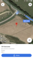
| Mon 29 Jun 2020 in 50,-3: 50.7349175, -3.6243047 geohashing.info google osm bing/os kml crox |
Location
In a field someway past Whitestone, near Pathfinder Village.
Participants
Expedition
Departed around 15.35 and cycled northwest out of Exeter, taking a brief diversion to avoid the steep part of the hill of Redhills. Encountered several birds, photographed one. Passed a path down into Barley Valley Nature Reserve that might have been worth exploring but didn't.
Continued on to Nadderwater. At the top of Redhills thought I smelled a barbecue and/or bonfire. Expected to turn west to cross the Nadder Brook but never noticed it, instead following the road through the village and beyond. Later realised the small stream under the road was the waterway in question and felt somewhat underwhelmed.
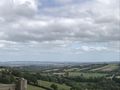
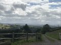
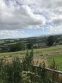
Headed west to Whitestone. Along the way took a break to observe a pair of ambivalent horses (one pictured). Passed through Whitestone uneventfully. At some point along this stretched passed a pair of horse riders. The road from Whitestone to the geohash included several gates looking south, offering a wide view of the valley. One gate lead to Ramslade Farm, which had a rather artistic depiction of a common Devonshire pheasant on its sign.
Reached the geohash field, which was open. Stepped just inside the field before hearing angry barking and spotting a pair of dogs running up the path, and duly left. Took stupid grin photo from as near as I could get, along with visual on the geohash. Debated whether this counted as a successful expedition but later decided against it.
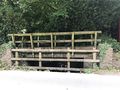
On passing back through Whitestone, noticed a plough that had been donated for ornamentation, presumably by the family of a local farmer. In Nadderwater discovered a plaque detailing the story of the Trafalgar Way, part of which I had followed for my expedition. Returned around 17.30.
Photos
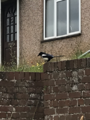
1/several birds
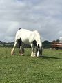
Ambivalent horse
Looking East (towards Exeter)
Looking West (towards the moor)
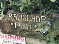
A pheasant (artist's rendition)


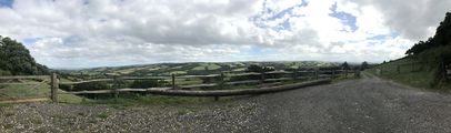 The entire view

Proof
The geohash, in there somewhere
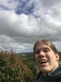
Stupid grinTM
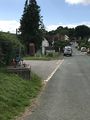
Village of Whitestone
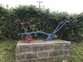
Ornamental plough
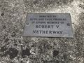
Plaque for the plough
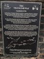
Fascinating local history
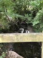
The river through Nadderwater
The bridge over the river
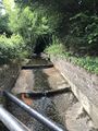
The other end of the river


Achievements
Harowcal earned the No trespassing consolation prize
|