Difference between revisions of "2020-07-11 32 -116"
From Geohashing
([live picture]Tacate is an inactive graticule. I am an inactive geohasher. Could that change on 7/11? This expedition is in the Cleveland National Forest about 1/10th of a mile from the Sunset Trail and about 1/3 of a mile from the trailhead at Sunri...) |
(Changed new report to planning) |
||
| Line 50: | Line 50: | ||
<!-- =============== USEFUL CATEGORIES FOLLOW ================ | <!-- =============== USEFUL CATEGORIES FOLLOW ================ | ||
Delete the next line ONLY if you have chosen the appropriate categories below. If you are unsure, don't worry. People will read your report and help you with the classification. --> | Delete the next line ONLY if you have chosen the appropriate categories below. If you are unsure, don't worry. People will read your report and help you with the classification. --> | ||
| + | <!-- | ||
[[Category:New report]] | [[Category:New report]] | ||
| − | + | --> | |
<!-- ==REQUEST FOR TWITTER BOT== Please leave either the New report or the Expedition planning category in as long as you work on it. This helps the twitter bot a lot with announcing the right outcome at the right moment. --> | <!-- ==REQUEST FOR TWITTER BOT== Please leave either the New report or the Expedition planning category in as long as you work on it. This helps the twitter bot a lot with announcing the right outcome at the right moment. --> | ||
<!-- Potential categories. Please include all the ones appropriate to your expedition --> | <!-- Potential categories. Please include all the ones appropriate to your expedition --> | ||
| − | |||
[[Category:Expedition planning]] | [[Category:Expedition planning]] | ||
| − | |||
<!-- If all those plans are never acted upon, change [[Category:Expedition planning]] to [[Category:Not reached - Did not attempt]]. --> | <!-- If all those plans are never acted upon, change [[Category:Expedition planning]] to [[Category:Not reached - Did not attempt]]. --> | ||
Revision as of 16:01, 10 July 2020
| Sat 11 Jul 2020 in 32,-116: 32.8637221, -116.4672808 geohashing.info google osm bing/os kml crox |
Location
Participants
Plans
Expedition
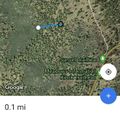
- I am tempted to undertake an expedition. This graticule has been long inactive as have I. The hash point is about 1/10th of a mile off trail in the Cleveland National Forest within easy reach of the Sunset Trailhead. No water is available but parking and portable bathrooms are on site. Please message me if you want to attempt a socially distant meetup. -- Scerruti (talk) @33.2455,-117.3274 08:47, 10 July 2020 (PDT)
Tracklog
Photos
Tacate is an inactive graticule. I am an inactive geohasher. Could that change on 7/11?
- This expedition is in the Cleveland National Forest about 1/10th of a mile from the Sunset Trail and about 1/3 of a mile from the trailhead at Sunrise Highway. Parking and portable bathrooms are available on site but no water.
- If you are interested please contact me so we can plan a socially distant meetup.

Achievements