Difference between revisions of "2020-08-25 47 -122"
From Geohashing
([live picture]No access [https://openstreetmap.org/?lat=47.54701490&lon=-122.06195810&zoom=16&layers=B000FTF @47.5470,-122.0620]) |
([live picture]No sidewalk [https://openstreetmap.org/?lat=47.54680450&lon=-122.06231910&zoom=16&layers=B000FTF @47.5468,-122.0623]) |
||
| Line 38: | Line 38: | ||
Image:2020-08-25_47_-122_thomcat_1598401570830.jpg|No access [https://openstreetmap.org/?lat=47.54701490&lon=-122.06195810&zoom=16&layers=B000FTF @47.5470,-122.0620] | Image:2020-08-25_47_-122_thomcat_1598401570830.jpg|No access [https://openstreetmap.org/?lat=47.54701490&lon=-122.06195810&zoom=16&layers=B000FTF @47.5470,-122.0620] | ||
| + | |||
| + | Image:2020-08-25_47_-122_thomcat_1598401856814.jpg|No sidewalk [https://openstreetmap.org/?lat=47.54680450&lon=-122.06231910&zoom=16&layers=B000FTF @47.5468,-122.0623] | ||
</gallery> | </gallery> | ||
Revision as of 00:31, 26 August 2020
| Tue 25 Aug 2020 in 47,-122: 47.5472435, -122.0619352 geohashing.info google osm bing/os kml crox |
Location
Participants
Plans
Expedition
Tracklog
Photos

Nearly there @47.5480,-122.0627
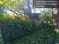
No access @47.5470,-122.0620
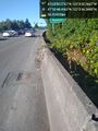
No sidewalk @47.5468,-122.0623


Achievements