Difference between revisions of "2020-10-04 47 8"
(→Photos) |
|||
| Line 45: | Line 45: | ||
<!-- =============== USEFUL CATEGORIES FOLLOW ================ | <!-- =============== USEFUL CATEGORIES FOLLOW ================ | ||
| − | |||
| − | |||
| − | |||
| − | |||
| − | |||
| − | |||
| − | |||
| − | |||
| − | |||
| − | |||
| − | |||
| − | |||
| − | |||
[[Category:Expeditions]] | [[Category:Expeditions]] | ||
| − | |||
[[Category:Expeditions with photos]] | [[Category:Expeditions with photos]] | ||
| − | |||
| − | |||
| − | |||
| − | |||
| − | |||
[[Category:Coordinates reached]] | [[Category:Coordinates reached]] | ||
| − | |||
| − | |||
| − | |||
| − | |||
| − | |||
| − | |||
| − | |||
| − | |||
| − | |||
| − | |||
| − | |||
| − | |||
| − | |||
| − | |||
| − | |||
| − | |||
| − | |||
| − | |||
Revision as of 20:28, 4 October 2020
| Sun 4 Oct 2020 in 47,8: 47.3921119, 8.3739426 geohashing.info google osm bing/os kml crox |
Location
On a field near Kindhausen.
Participants
Plans
Take the bus 305 to Kindhausen and walk to the hashpoint - like two days ago.
Expedition
Two days ago I visited the GeoCache GC4YGJE Der Nachtwächter. Soon later I checked the website to see where the Geohashes for the weekend are. The one for Sunday was just a few meters away and in plain sight! With the clock at 17:28+02:00 the hashes where already 2h out however. Any way, today I had to visit the place again. Just for the memory of this coincidence. Near the hash is a tiny pond a bit hidden. It's a nice location - on Sundays: There is a army shooting range near by and they are quiet loud with all that explosives they "test" there.
The trip was uneventful.
Tracklog

Red is the track from Friday, green the one from Sunday.
Photos
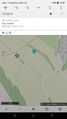
Where was I when I checked the hashpoints for the weekend? But I was two hours late for a Déjà vu.
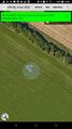
Destination reached
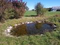
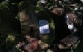
The pond. It's tiny!
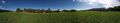
View from the hashpoint
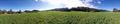
View from the hashpoint
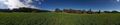
View from the hashpoint
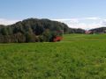
View from the hashpoint towards the GeoCache. The N is the nice cover of the cache!
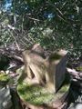
Bad bad picture, but though the bush the hashsite was clearly visible.
My two entries in to the log of the cache.
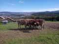
On the way back, I meet some cows.


