Difference between revisions of "2021-05-13 48 11"
Clearlucid9 (talk | contribs) (→Photos) |
Clearlucid9 (talk | contribs) (→Photos) |
||
| Line 19: | Line 19: | ||
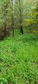
File:2021-05-13 16.45.03.jpg | into the undergrowth | File:2021-05-13 16.45.03.jpg | into the undergrowth | ||
File:2021-05-13 16.54.02.jpg | logproof (adjacent golf range visible in the satellite picture | File:2021-05-13 16.54.02.jpg | logproof (adjacent golf range visible in the satellite picture | ||
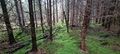
| − | File:2021-05-13 16.54.12.jpg | | + | File:2021-05-13 16.54.12.jpg | trees at hash |
| − | File:2021-05-13 16.54.16.jpg | | + | File:2021-05-13 16.54.16.jpg | more trees |
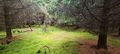
| − | File:2021-05-13 16.54.19.jpg | | + | File:2021-05-13 16.54.19.jpg | and yet more trees |
| − | File:2021-05-13 16.54.22.jpg | | + | File:2021-05-13 16.54.22.jpg | |
File:2021-05-13 16.54.33.jpg | | File:2021-05-13 16.54.33.jpg | | ||
</gallery> | </gallery> | ||
Revision as of 16:38, 13 May 2021
{meetup graticule | lat=48 | lon=11 | date=2021-05-13
Contents
Location
in a forest next to a golf course and driving range in Kirchstockach
Participants
Expedition
Father's Day in Germany - I had done some geocaching in the morning, but decided to take my bike to go for this hash in the late afternoon. Cycling there took me about 25 minutes and I got a little wet as it started to rain. I've been in this area just recently for a geocache, hence I know that I would need to take a gravel road across a golf course (visible in the GPS screenshot) - luckily no golf ball striking my had. But then again I was protected by my bicycle helmet anyway... According to Google there should have been a small path that would lead me close to the hash coordinates, but as I have realised many times in the past: Google is +/- useless in the "outback". Hence I had to find my way through ~150m of quite dense undergrowth till I got where I needed to be. GPS reception wasn't good here under the canopy and I had to move quite a bit forth and back to find the right spot. Once the GPS settled on a point I took my pictures. On the way back I was lucky and found a better way back to my bike.
Photos
footpath according to Google
into the undergrowth
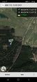
logproof (adjacent golf range visible in the satellite picture
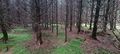
trees at hash
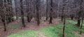
more trees
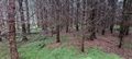
and yet more trees