Difference between revisions of "2021-07-08 50 7"
From Geohashing
Gefrierbrand (talk | contribs) ([retro picture]Autobahnbrücke [https://openstreetmap.org/?mlat=50.29987790&mlon=7.45931110&zoom=16 @50.2999,7.4593]) |
Gefrierbrand (talk | contribs) ([retro picture]schlossimhintergrund [https://openstreetmap.org/?mlat=50.29987970&mlon=7.45930280&zoom=16 @50.2999,7.4593]) |
||
| Line 56: | Line 56: | ||
Image:2021-07-08_50_7_Gefrierbrand_1625837822781.jpg|Autobahnbrücke [https://openstreetmap.org/?mlat=50.29987790&mlon=7.45931110&zoom=16 @50.2999,7.4593] | Image:2021-07-08_50_7_Gefrierbrand_1625837822781.jpg|Autobahnbrücke [https://openstreetmap.org/?mlat=50.29987790&mlon=7.45931110&zoom=16 @50.2999,7.4593] | ||
| + | |||
| + | Image:2021-07-08_50_7_Gefrierbrand_1625837842462.jpg|schlossimhintergrund [https://openstreetmap.org/?mlat=50.29987970&mlon=7.45930280&zoom=16 @50.2999,7.4593] | ||
</gallery> | </gallery> | ||
Revision as of 13:37, 9 July 2021
| Thu 8 Jul 2021 in 50,7: 50.2833391, 7.5784299 geohashing.info google osm bing/os kml crox |
Location
In a forest near Waldesch
Participants
Plans
Expedition
Tracklog
Photos

StupidGrinTM
- 2021-07-08 50 7 Gefrierbrand 1625837565212.jpg
view @50.2999,7.4593
- 2021-07-08 50 7 Gefrierbrand 1625837590050.jpg
proof @50.2999,7.4593
- 2021-07-08 50 7 Gefrierbrand 1625837617912.jpg
binoculars statue @50.2999,7.4593
- 2021-07-08 50 7 Gefrierbrand 1625837642484.jpg
nontrivial terrain @50.2999,7.4593
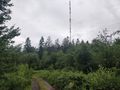
radio tower @50.2999,7.4593
bike through there? @50.2999,7.4593
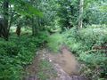
dead end @50.2999,7.4593

nice road to start @50.2999,7.4593
- 2021-07-08 50 7 Gefrierbrand 1625837789599.jpg
wet feet @50.2999,7.4593
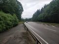
- 2021-07-08 50 7 Gefrierbrand 1625837822781.jpg
Autobahnbrücke @50.2999,7.4593
- 2021-07-08 50 7 Gefrierbrand 1625837842462.jpg
schlossimhintergrund @50.2999,7.4593


Achievements