Difference between revisions of "2021-07-26 50 7"
From Geohashing
Gefrierbrand (talk | contribs) ([retro picture]viadukt [https://openstreetmap.org/?mlat=50.29988370&mlon=7.45931540&zoom=16 @50.2999,7.4593]) |
Gefrierbrand (talk | contribs) ([retro picture]tunnel [https://openstreetmap.org/?mlat=50.29987990&mlon=7.45931130&zoom=16 @50.2999,7.4593]) |
||
| Line 48: | Line 48: | ||
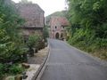
Image:2021-07-26_50_7_Gefrierbrand_1627370553000.jpg|viadukt [https://openstreetmap.org/?mlat=50.29988370&mlon=7.45931540&zoom=16 @50.2999,7.4593] | Image:2021-07-26_50_7_Gefrierbrand_1627370553000.jpg|viadukt [https://openstreetmap.org/?mlat=50.29988370&mlon=7.45931540&zoom=16 @50.2999,7.4593] | ||
| + | |||
| + | Image:2021-07-26_50_7_Gefrierbrand_1627370565964.jpg|tunnel [https://openstreetmap.org/?mlat=50.29987990&mlon=7.45931130&zoom=16 @50.2999,7.4593] | ||
</gallery> | </gallery> | ||
Revision as of 07:22, 27 July 2021
| Mon 26 Jul 2021 in 50,7: 50.3556627, 7.2709638 geohashing.info google osm bing/os kml crox |
Location
Participants
Plans
Expedition
Tracklog
Photos
Fancy Lighting @50.2999,7.4593
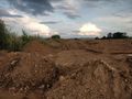
thats no road @50.2999,7.4593
birds! @50.2999,7.4593

stupid grin @50.2999,7.4593
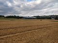
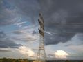
hashfield @50.2999,7.4593
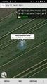
proof @50.2999,7.4593

viadukt @50.2999,7.4593

tunnel @50.2999,7.4593


Achievements