Difference between revisions of "2021-08-11 51 4"
From Geohashing
FelixTheCat (talk | contribs) (Created page with "{{subst:Expedition |lat = 51 |lon = 4 |date = 2021-08-11 }}") |
FelixTheCat (talk | contribs) |
||
| Line 1: | Line 1: | ||
| − | + | {{meetup graticule | |
| − | |||
| − | |||
| − | |||
| − | |||
| − | |||
| − | |||
| − | |||
| − | |||
| lat=51 | | lat=51 | ||
| lon=4 | | lon=4 | ||
| date=2021-08-11 | | date=2021-08-11 | ||
| − | }} | + | }} |
__NOTOC__ | __NOTOC__ | ||
== Location == | == Location == | ||
| − | + | On a field in Schipluiden, South Holland province. | |
== Participants == | == Participants == | ||
| − | + | [[User:FelixTheCat|FelixTheCat]] ([[User talk:FelixTheCat|talk]]) | |
| − | |||
| − | |||
| − | |||
| − | |||
== Expedition == | == Expedition == | ||
| − | + | Today's hash seemed to be on private property, on a farmer's field. However, it was so close to home that it would be a shame not to try it. I got on my bike a little after 20:00 and arrived at the field about fifteen minutes later. As I expected, the point was not accessible. I took a few pictures and went home again. | |
| − | |||
| − | |||
| − | |||
== Photos == | == Photos == | ||
| − | |||
| − | |||
| − | |||
<gallery perrow="5"> | <gallery perrow="5"> | ||
| + | Image:2021-08-11 51 4 FelixTheCat 1.JPG | Parked my bike next to the bike path. In the background is Schipluiden's golf course and the setting sun. | ||
| + | Image:2021-08-11 51 4 FelixTheCat 2.JPG | The hash field. | ||
| + | Image:2021-08-11 51 4 FelixTheCat 3.png | Failed! | ||
| + | Image:2021-08-11 51 4 FelixTheCat 4.JPG | Lloyd and Trix looking at the hash. | ||
| + | Image:2021-08-11 51 4 FelixTheCat 5.JPG | Nearby was this little bridge into the bush. | ||
| + | Image:2021-08-11 51 4 FelixTheCat 6.JPG | On the other side was this sculpture called "New Landscape". Rather unimpressive if you ask me. | ||
</gallery> | </gallery> | ||
== Achievements == | == Achievements == | ||
{{#vardefine:ribbonwidth|800px}} | {{#vardefine:ribbonwidth|800px}} | ||
| − | + | {{No trespassing | |
| − | + | | latitude = 51 | |
| − | + | | longitude = 4 | |
| − | + | | date = 2021-08-11 | |
| − | + | | name = [[User:FelixTheCat|FelixTheCat]] ([[User talk:FelixTheCat|talk]]) | |
| − | + | | distance = 36 m | |
| − | + | }} | |
| − | |||
| − | |||
| − | |||
| − | |||
| − | |||
| − | |||
| − | |||
| − | |||
| − | |||
[[Category:Expeditions]] | [[Category:Expeditions]] | ||
| − | |||
[[Category:Expeditions with photos]] | [[Category:Expeditions with photos]] | ||
| − | |||
| − | |||
| − | |||
| − | |||
| − | |||
| − | |||
| − | |||
| − | |||
| − | |||
[[Category:Coordinates not reached]] | [[Category:Coordinates not reached]] | ||
| − | |||
| − | |||
| − | |||
| − | |||
| − | |||
[[Category:Not reached - No public access]] | [[Category:Not reached - No public access]] | ||
| − | |||
| − | |||
| − | |||
| − | |||
| − | |||
| − | |||
| − | |||
| − | |||
Revision as of 15:37, 14 August 2021
| Wed 11 Aug 2021 in 51,4: 51.9726811, 4.3306775 geohashing.info google osm bing/os kml crox |
Location
On a field in Schipluiden, South Holland province.
Participants
Expedition
Today's hash seemed to be on private property, on a farmer's field. However, it was so close to home that it would be a shame not to try it. I got on my bike a little after 20:00 and arrived at the field about fifteen minutes later. As I expected, the point was not accessible. I took a few pictures and went home again.
Photos
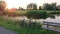
Parked my bike next to the bike path. In the background is Schipluiden's golf course and the setting sun.
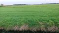
The hash field.
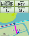
Failed!
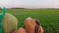
Lloyd and Trix looking at the hash.
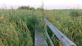
Nearby was this little bridge into the bush.
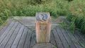
On the other side was this sculpture called "New Landscape". Rather unimpressive if you ask me.


Achievements
FelixTheCat (talk) earned the No trespassing consolation prize
|