Difference between revisions of "2021-09-07 51 8"
FelixTheCat (talk | contribs) (Created page with "{{subst:Expedition |lat = 51 |lon = 8 |date = 2021-09-07 }}") |
FelixTheCat (talk | contribs) m |
||
| (2 intermediate revisions by 2 users not shown) | |||
| Line 1: | Line 1: | ||
| − | + | {{meetup graticule | |
| − | |||
| − | |||
| − | |||
| − | |||
| − | |||
| − | |||
| − | |||
| − | |||
| lat=51 | | lat=51 | ||
| lon=8 | | lon=8 | ||
| date=2021-09-07 | | date=2021-09-07 | ||
| − | }} | + | }} |
__NOTOC__ | __NOTOC__ | ||
== Location == | == Location == | ||
| − | + | In Lennestadt-Altenhundem, North Rhine-Westphalia, Germany. | |
== Participants == | == Participants == | ||
| − | + | * [[User:FelixTheCat|FelixTheCat]] ([[User talk:FelixTheCat|talk]]) | |
| − | + | * Kat the Awesome | |
| − | |||
| − | |||
| − | |||
== Expedition == | == Expedition == | ||
| − | + | Kat and I were on vacation in the Sauerland area when this hash popped up. It was sort of nearby, so we decided to visit it. The drive there was good, on winding country roads through hilly landscapes. When we arrived in Altenhundem we parked the hashmobile and walked the last bit. The hash was on a hill on the edge of the town, so we followed a path uphill until we got close. Unfortunately the hash was on a very steep area, and there was a fence blocking off that part of the hill. It was an old and dilapidated fence, but a fence nonetheless. We took a few pictures and then drove back to our hotel. | |
| − | |||
| − | |||
| − | |||
== Photos == | == Photos == | ||
| Line 34: | Line 20: | ||
--> | --> | ||
<gallery perrow="5"> | <gallery perrow="5"> | ||
| + | Image:2021-09-07 51 8 FelixTheCat 1.JPG | We've arrived in Altenhundem and parked the car at Hundemaue. | ||
| + | Image:2021-09-07 51 8 FelixTheCat 2.JPG | This cute little bridge takes us across the river Hundem. | ||
| + | Image:2021-09-07 51 8 FelixTheCat 3.JPG | Behind some houses is this little path going up the hill. | ||
| + | Image:2021-09-07 51 8 FelixTheCat 4.JPG | It becomes a grassy path as we climb a bit higher. | ||
| + | Image:2021-09-07 51 8 FelixTheCat 5.png | Unfortunately, this is as close as we get. | ||
| + | Image:2021-09-07 51 8 FelixTheCat 6.JPG | Lloyd looking at the fence, with the hash somewhere up there. You can't really tell from the picture, but it would've been a very steep climb too. | ||
</gallery> | </gallery> | ||
== Achievements == | == Achievements == | ||
{{#vardefine:ribbonwidth|800px}} | {{#vardefine:ribbonwidth|800px}} | ||
| − | + | {{No trespassing | |
| − | + | | latitude = 51 | |
| − | + | | longitude = 8 | |
| − | + | | date = 2021-09-07 | |
| − | + | | name = [[User:FelixTheCat|FelixTheCat]] ([[User talk:FelixTheCat|talk]]) and Kat | |
| − | + | | distance = 39 m | |
| − | + | }} | |
| − | |||
| − | |||
| − | |||
| − | [[ | ||
| − | |||
| − | |||
| − | |||
| − | |||
| − | |||
[[Category:Expeditions]] | [[Category:Expeditions]] | ||
| − | |||
[[Category:Expeditions with photos]] | [[Category:Expeditions with photos]] | ||
| − | |||
| − | |||
| − | |||
| − | |||
| − | |||
| − | |||
| − | |||
| − | |||
| − | |||
[[Category:Coordinates not reached]] | [[Category:Coordinates not reached]] | ||
| − | |||
| − | |||
| − | |||
| − | |||
| − | |||
[[Category:Not reached - No public access]] | [[Category:Not reached - No public access]] | ||
| − | + | {{location|DE|NW|OE}} | |
| − | |||
| − | |||
| − | |||
| − | |||
| − | |||
| − | |||
| − | |||
Latest revision as of 21:14, 24 November 2022
| Tue 7 Sep 2021 in 51,8: 51.0936213, 8.0620999 geohashing.info google osm bing/os kml crox |
Location
In Lennestadt-Altenhundem, North Rhine-Westphalia, Germany.
Participants
- FelixTheCat (talk)
- Kat the Awesome
Expedition
Kat and I were on vacation in the Sauerland area when this hash popped up. It was sort of nearby, so we decided to visit it. The drive there was good, on winding country roads through hilly landscapes. When we arrived in Altenhundem we parked the hashmobile and walked the last bit. The hash was on a hill on the edge of the town, so we followed a path uphill until we got close. Unfortunately the hash was on a very steep area, and there was a fence blocking off that part of the hill. It was an old and dilapidated fence, but a fence nonetheless. We took a few pictures and then drove back to our hotel.
Photos
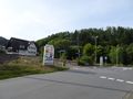
We've arrived in Altenhundem and parked the car at Hundemaue.
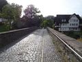
This cute little bridge takes us across the river Hundem.
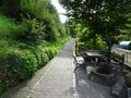
Behind some houses is this little path going up the hill.
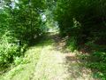
It becomes a grassy path as we climb a bit higher.
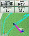
Unfortunately, this is as close as we get.
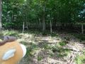
Lloyd looking at the fence, with the hash somewhere up there. You can't really tell from the picture, but it would've been a very steep climb too.


Achievements
FelixTheCat (talk) and Kat earned the No trespassing consolation prize
|