Difference between revisions of "2022-03-21 49 8"
Gefrierbrand (talk | contribs) ([retro picture]Hut) |
(can't see any videos) |
||
| (13 intermediate revisions by 2 users not shown) | |||
| Line 1: | Line 1: | ||
| − | + | {{meetup graticule | |
| − | |||
| − | |||
| − | |||
| − | |||
| − | |||
| − | |||
| − | |||
| − | |||
| lat=49 | | lat=49 | ||
| lon=8 | | lon=8 | ||
| date=2022-03-21 | | date=2022-03-21 | ||
| − | }} | + | }} |
__NOTOC__ | __NOTOC__ | ||
== Location == | == Location == | ||
| − | + | on a disused path in a forest near Roßdorf | |
== Participants == | == Participants == | ||
| − | + | *[[User:Santu|Santu]] | |
| − | + | *[[User:Gefrierbrand|Gefrierbrand]] | |
| + | *Pedro the dog | ||
| − | == | + | == Expedition == |
| − | + | We started from a parkinglot near Roßdorf and walked on nice big gravel paths towards the hash. The maps had indicated a narrow passage from the south, which was blocked by a laid down tree deliberately placed there as a barrier. But there was still a possibility to get to it from the north. | |
| − | + | So we walked around and tried to get to the hash from the other side. It would have been possible and quite easy to reach, but a sign kindly asked us to stay away to preserve the local wildlife and we therefore could only get to within 40 m. | |
| − | |||
| + | Undeterred by that, we explored the area and had fun climbing onto large fallen trees and into conically arranged hovels made out of wood pieces. Gefierbrand even fell down without any harm done. | ||
| − | + | As google maps had suggested we might see some teddy bears nailed to trees in the "birthday avenue", we went there to have a look. Unbeknownst to us, all the pictures we had seen online were 20 years old an no stuffed animals were actually remaining there. We did however find lots of small plaques indicating names and birthdays of many children before walking back and returning home. | |
== Tracklog == | == Tracklog == | ||
| − | + | {{tracklog | T2022-03-21 49 8.gpx}} | |
== Photos == | == Photos == | ||
| − | + | ||
| − | |||
| − | |||
<gallery perrow="5"> | <gallery perrow="5"> | ||
| − | + | Image:2022-03-21_49_8_Gefrierbrand_1647961279187.jpg|Pedro in a collection of pieces of wood arranged in a cone | |
| − | Image:2022-03-21_49_8_Gefrierbrand_1647960170192.jpg| | + | Image:2022-03-21_49_8_Gefrierbrand_1647960210274.jpg|Santu in a hovel |
| − | + | Image:2022-03-21_49_8_Gefrierbrand_1647960245664.jpg|no trespassing | |
| − | Image:2022-03- | + | Image:2022-03-21_49_8_Gefrierbrand_1647960372777.jpg|hash location visible yet unreachable |
| + | Image:2022-03-21_49_8_Gefrierbrand_1647960284231.jpg|Santus climbing adventure | ||
| + | Image:2022-03-21_49_8_Gefrierbrand_1647961243224.jpg|Gefrierbrand balancing | ||
| + | Image:2022-03-21_49_8_Gefrierbrand_1647961255214.jpg|StupidGrin<sup>TM</sup> | ||
| + | Image:2022-03-21_49_8_Gefrierbrand_1647960170192.jpg|birthday avenue | ||
| + | Image:2022-03-21_49_8_Gefrierbrand_1647960314430.jpg|so close | ||
</gallery> | </gallery> | ||
== Achievements == | == Achievements == | ||
{{#vardefine:ribbonwidth|800px}} | {{#vardefine:ribbonwidth|800px}} | ||
| − | + | {{No trespassing | |
| − | + | | latitude = 49 | |
| − | + | | longitude = 8 | |
| − | + | | date = 2022-03-21 | |
| − | + | | name = Gefrierbrand & Santu | |
| − | + | | distance = 40 m | |
| − | + | }} | |
| − | |||
| − | |||
| − | |||
| − | |||
| − | |||
| − | |||
| − | |||
| − | |||
| − | |||
[[Category:Expeditions]] | [[Category:Expeditions]] | ||
| − | |||
[[Category:Expeditions with photos]] | [[Category:Expeditions with photos]] | ||
| − | |||
| − | |||
| − | |||
| − | |||
| − | |||
| − | |||
| − | |||
| − | |||
| − | |||
[[Category:Coordinates not reached]] | [[Category:Coordinates not reached]] | ||
| − | |||
| − | |||
| − | |||
| − | |||
| − | |||
[[Category:Not reached - No public access]] | [[Category:Not reached - No public access]] | ||
| − | + | [[Category:Expeditions with dogs]] | |
| − | + | {{location|DE|HE|DA}} | |
| − | [[Category: | ||
| − | |||
| − | |||
| − | |||
| − | |||
| − | |||
Latest revision as of 14:59, 24 October 2022
| Mon 21 Mar 2022 in 49,8: 49.8785708, 8.7606050 geohashing.info google osm bing/os kml crox |
Location
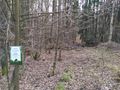
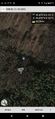
on a disused path in a forest near Roßdorf
Participants
- Santu
- Gefrierbrand
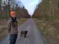
- Pedro the dog
Expedition
We started from a parkinglot near Roßdorf and walked on nice big gravel paths towards the hash. The maps had indicated a narrow passage from the south, which was blocked by a laid down tree deliberately placed there as a barrier. But there was still a possibility to get to it from the north.
So we walked around and tried to get to the hash from the other side. It would have been possible and quite easy to reach, but a sign kindly asked us to stay away to preserve the local wildlife and we therefore could only get to within 40 m.
Undeterred by that, we explored the area and had fun climbing onto large fallen trees and into conically arranged hovels made out of wood pieces. Gefierbrand even fell down without any harm done.
As google maps had suggested we might see some teddy bears nailed to trees in the "birthday avenue", we went there to have a look. Unbeknownst to us, all the pictures we had seen online were 20 years old an no stuffed animals were actually remaining there. We did however find lots of small plaques indicating names and birthdays of many children before walking back and returning home.
Tracklog
Photos
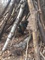
Pedro in a collection of pieces of wood arranged in a cone
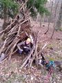
Santu in a hovel
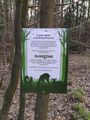
no trespassing
hash location visible yet unreachable
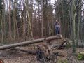
Santus climbing adventure
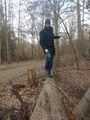
Gefrierbrand balancing

StupidGrinTM
birthday avenue
so close


Achievements
Gefrierbrand & Santu earned the No trespassing consolation prize
|