Difference between revisions of "2022-04-10 52 9"
(rough plan) |
(No tespassing ribon) |
||
| (4 intermediate revisions by 2 users not shown) | |||
| Line 27: | Line 27: | ||
== Expedition == | == Expedition == | ||
| − | |||
| − | + | Seeing the weather in the early afternoon, I had second thoughts on my plan. | |
| − | + | But since I had already commited on going, I waited for a short rain shower to end and set out on my bike. | |
| + | There was a stiff westerly wind, with occasional rain and hail showers. | ||
| + | At around 15:30, I reached the closest distance to the location at around 150m. | ||
| + | Unfortunately, the whole area consisted of fenced paddocks and hunting grounds, so I could not leave the track. | ||
| + | After contemplating the area, I took a different way to head home again. | ||
| + | There were still occasional showers, but now, I had the wind from behind. | ||
== Photos == | == Photos == | ||
| Line 37: | Line 41: | ||
--> | --> | ||
<gallery perrow="5"> | <gallery perrow="5"> | ||
| + | Image:2022-04-10 52 9 house.jpg | A nice town house in Wunstorf. | ||
| + | Image:2022-04-10 52 9 Düendorf.jpg | Approching Düendorf manor. | ||
| + | Image:2022-04-10 52 9 almost there.jpg | Almost there... | ||
| + | Image:2022-04-10 52 9 Mittellandkanal.jpg | Riding along the Mittellandkanal. | ||
| + | Image:2022-04-10 52 9 boat.jpg | Traffic on the canal (not representative). | ||
</gallery> | </gallery> | ||
== Achievements == | == Achievements == | ||
{{#vardefine:ribbonwidth|800px}} | {{#vardefine:ribbonwidth|800px}} | ||
| − | + | {{No trespassing | |
| + | | latitude = 52 | ||
| + | | longitude = 9 | ||
| + | | date = 2022-04-10 | ||
| + | | name = [[User:DLichti|DLichti]] | ||
| + | | distance = 150m | ||
| + | }} | ||
| − | |||
| − | |||
| − | |||
| − | |||
| − | |||
| − | |||
| − | |||
| − | |||
| − | |||
| − | |||
| − | |||
| − | |||
| − | |||
| − | |||
[[Category:Expeditions]] | [[Category:Expeditions]] | ||
| − | |||
[[Category:Expeditions with photos]] | [[Category:Expeditions with photos]] | ||
| − | |||
| − | |||
| − | |||
| − | |||
| − | |||
| − | |||
| − | |||
| − | |||
| − | |||
[[Category:Coordinates not reached]] | [[Category:Coordinates not reached]] | ||
| − | |||
| − | |||
| − | |||
| − | |||
| − | |||
[[Category:Not reached - No public access]] | [[Category:Not reached - No public access]] | ||
| − | + | {{location|DE|NI|H}} | |
| − | |||
| − | |||
| − | |||
| − | |||
| − | |||
| − | |||
| − | |||
Latest revision as of 07:59, 16 April 2022
| Sun 10 Apr 2022 in 52,9: 52.4018778, 9.4164676 geohashing.info google osm bing/os kml crox |
Location
At the edge of the forest near Düendorf manor.
Participants
Plans
Take the bike, be there some time in the afternoon.
Expedition
Seeing the weather in the early afternoon, I had second thoughts on my plan. But since I had already commited on going, I waited for a short rain shower to end and set out on my bike. There was a stiff westerly wind, with occasional rain and hail showers. At around 15:30, I reached the closest distance to the location at around 150m. Unfortunately, the whole area consisted of fenced paddocks and hunting grounds, so I could not leave the track. After contemplating the area, I took a different way to head home again. There were still occasional showers, but now, I had the wind from behind.
Photos
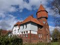
A nice town house in Wunstorf.
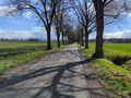
Approching Düendorf manor.
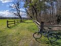
Almost there...
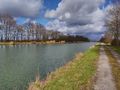
Riding along the Mittellandkanal.
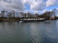
Traffic on the canal (not representative).


Achievements
DLichti earned the No trespassing consolation prize
|