Difference between revisions of "2022-05-14 41 -79"
From Geohashing
(→Achievements) |
|||
| Line 53: | Line 53: | ||
{{#vardefine:ribbonwidth|800px}} | {{#vardefine:ribbonwidth|800px}} | ||
<!-- Add any achievement ribbons you earned below, or remove this section --> | <!-- Add any achievement ribbons you earned below, or remove this section --> | ||
| + | {{land geohash | ||
| + | |||
| + | | latitude = 41 | ||
| + | | longitude = -79 | ||
| + | | date = 2022-05-14 | ||
| + | | name = kc3qja | ||
| + | | image = | ||
| + | }} | ||
| + | |||
| + | I was out standing in the field. | ||
| + | [[File:2016-04-22 52 1 Sourcerer Trophy.jpg|400px]] | ||
<!-- =============== USEFUL CATEGORIES FOLLOW ================ | <!-- =============== USEFUL CATEGORIES FOLLOW ================ | ||
Revision as of 01:30, 15 May 2022
| Sat 14 May 2022 in 41,-79: 41.2534716, -79.8995156 geohashing.info google osm bing/os kml crox |
Location
The hash was in a field near Bullion, PA.
Participants
Plans
The plan was to just go there. I wasn't sure if it was posted or not, so I had to find out.
Expedition
Took the car to Bullion where me and my stepdad got out and walked a quarter mile to the hash. Didn't run into anyone except a shack, and didn't know if we were trespassing or not.
Tracklog
I don't know what a tracklog is. Here is a photo of my phone showing proof of location.

Photos
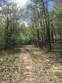
Trail at the hash.
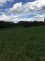
Photo taken at the hash.


Achievements
kc3qja earned the Land geohash achievement
|
I was out standing in the field.
