Difference between revisions of "2022-05-19 53 6"
(Documenting the plan) |
(Documenting the expedition) |
||
| Line 12: | Line 12: | ||
== Plans == | == Plans == | ||
| − | We're going with a car which we can hopefully park nearby. Then we need to walk about a kilometer to see if the hash can be reached without a boat. Google maps says it's water, openstreetmap says it's not, and Google's | + | We're going with a car which we can hopefully park nearby. Then we need to walk about a kilometer to see if the hash can be reached without a boat. Google maps says it's water, openstreetmap says it's not, and Google's satellite view suggests that it may not be. |
== Expedition == | == Expedition == | ||
| − | + | We parked the car close to the hash and walked to it. There was a train track in between, but we had seen a crossing close to the hash. Unfortunately, that crossing was apparently only for maintenance, because there were locked gates on both sides of it. So we had to drive several kilometers to cross the track. | |
| + | |||
| + | On the other side, as we had seen on the satellite images, was a path where cars were not allowed. There was a sign saying it was for bicycles only, "dus niet brommen" which is supposed to mean that scooters are not allowed, but it can also mean you're not allowed to complain. Which is much more funny. | ||
| + | |||
| + | We walked along that path towards the hash. It was a very nice walk, through a nature reserve. It was also nice weather, which was a pleasant surprise, as it had been raining just before. We had taken umbrellas with us just in case it would rain again, but it didn't. Instead, they were useful to provide shade from the sun. | ||
| + | |||
| + | In the nature reserve we saw cows and horses, and it was just a great view in general. But as was clear long before we got there, the hash was behind the fence, so we could not reach it. But we were not disappointed; we had a great hike through a very nice place. Although it means Shevek couldn't claim another Drag-Along achievement, the expedition was a nevertheless a success as far as we were concerned! | ||
== Tracklog == | == Tracklog == | ||
| − | + | [https://www.alltrails.com/explore/recording/2022-05-19-16-40-thu-46d0671 Track] | |
== Photos == | == Photos == | ||
| − | |||
| − | |||
| − | |||
<gallery perrow="5"> | <gallery perrow="5"> | ||
| + | Image:2022-05-19 53 6 windmill.jpg | We had to park the car next to an old windmill. | ||
| + | Image:2022-05-19 53 6 fietspad.jpg | No complaining allowed! | ||
| + | Image:2022-05-19 53 6 nature1.jpg | A nice view on the way to the hash. | ||
| + | Image:2022-05-19 53 6 gate.jpg | Next to the hash was a gate into the reserve, with a sign saying we couldn't enter. | ||
| + | Image:2022-05-19 53 6 hash1.jpg | A view of the hash point from the gate. | ||
| + | Image:2022-05-19 53 6 hash2.jpg | And one from the closest point on the path, about 50 m. | ||
| + | Image:2022-05-19 53 6 horses.jpg | Some horses along the way back. | ||
| + | Image:2022-05-19 53 6 nature2.jpg | More nature, this time with a bridge. | ||
| + | Image:2022-05-19 53 6 food.jpg | After the hike, we decided to get something to eat. | ||
</gallery> | </gallery> | ||
== Achievements == | == Achievements == | ||
{{#vardefine:ribbonwidth|800px}} | {{#vardefine:ribbonwidth|800px}} | ||
| − | + | {{No trespassing | |
| − | |||
| − | |||
| − | |||
| − | |||
| − | |||
| − | |||
| − | + | | latitude = 53 | |
| − | + | | longitude = 6 | |
| + | | date = 2022-05-19 | ||
| + | | name = Shevek | ||
| + | | image = 2022-05-19_53_6_gate.jpg | ||
| + | | distance = 50 m | ||
| − | + | }} | |
| − | |||
[[Category:Expeditions]] | [[Category:Expeditions]] | ||
| − | |||
[[Category:Expeditions with photos]] | [[Category:Expeditions with photos]] | ||
| − | |||
| − | |||
| − | |||
| − | |||
| − | |||
| − | |||
| − | |||
| − | |||
| − | |||
[[Category:Coordinates not reached]] | [[Category:Coordinates not reached]] | ||
| − | |||
| − | |||
| − | |||
| − | |||
| − | |||
[[Category:Not reached - No public access]] | [[Category:Not reached - No public access]] | ||
| − | |||
| − | |||
| − | |||
| − | |||
| − | |||
| − | |||
| − | |||
| − | |||
| − | |||
[[Category:Shevek]] | [[Category:Shevek]] | ||
Revision as of 23:18, 19 May 2022
| Thu 19 May 2022 in 53,6: 53.1708467, 6.6887653 geohashing.info google osm bing/os kml crox |
Location
Next to a bicycle path, which may be a swamp.
Participants
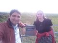
Shevek (talk) (dragging along a friend)
Plans
We're going with a car which we can hopefully park nearby. Then we need to walk about a kilometer to see if the hash can be reached without a boat. Google maps says it's water, openstreetmap says it's not, and Google's satellite view suggests that it may not be.
Expedition
We parked the car close to the hash and walked to it. There was a train track in between, but we had seen a crossing close to the hash. Unfortunately, that crossing was apparently only for maintenance, because there were locked gates on both sides of it. So we had to drive several kilometers to cross the track.
On the other side, as we had seen on the satellite images, was a path where cars were not allowed. There was a sign saying it was for bicycles only, "dus niet brommen" which is supposed to mean that scooters are not allowed, but it can also mean you're not allowed to complain. Which is much more funny.
We walked along that path towards the hash. It was a very nice walk, through a nature reserve. It was also nice weather, which was a pleasant surprise, as it had been raining just before. We had taken umbrellas with us just in case it would rain again, but it didn't. Instead, they were useful to provide shade from the sun.
In the nature reserve we saw cows and horses, and it was just a great view in general. But as was clear long before we got there, the hash was behind the fence, so we could not reach it. But we were not disappointed; we had a great hike through a very nice place. Although it means Shevek couldn't claim another Drag-Along achievement, the expedition was a nevertheless a success as far as we were concerned!
Tracklog
Photos
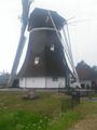
We had to park the car next to an old windmill.
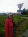
No complaining allowed!
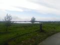
A nice view on the way to the hash.
Next to the hash was a gate into the reserve, with a sign saying we couldn't enter.
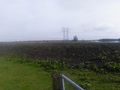
A view of the hash point from the gate.
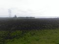
And one from the closest point on the path, about 50 m.
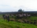
Some horses along the way back.
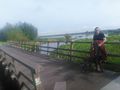
More nature, this time with a bridge.
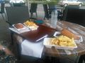
After the hike, we decided to get something to eat.


Achievements
Shevek earned the No trespassing consolation prize
|