Difference between revisions of "2022-05-30 39 -85"
m (Fippe moved page 2022-05-30 39 -86 to 2022-05-30 39 -85 without leaving a redirect: Typo) |
m (small fixes) |
||
| Line 1: | Line 1: | ||
{{meetup graticule | {{meetup graticule | ||
| − | | lat=39 | + | | lat=39 |
| − | | lon=-85 | + | | lon=-85 |
| date=2022-05-30 | | date=2022-05-30 | ||
| graticule_name=Burney-Clay Township | | graticule_name=Burney-Clay Township | ||
| − | | graticule_link= | + | | graticule_link=Greensburg, Indiana}} |
| − | |||
== Location == | == Location == | ||
| Line 12: | Line 11: | ||
== Participants == | == Participants == | ||
| − | *Hope | + | *[[User:Capricorn5|Hope]] |
== Expedition == | == Expedition == | ||
| Line 32: | Line 31: | ||
</gallery> | </gallery> | ||
| − | + | __NOTOC__ | |
[[Category:Expeditions]] | [[Category:Expeditions]] | ||
[[Category:Coordinates not reached]] | [[Category:Coordinates not reached]] | ||
[[Category:Not reached - No public access]] | [[Category:Not reached - No public access]] | ||
| − | {{location|US|IN| | + | {{location|US|IN|DC}} |
Latest revision as of 23:31, 30 May 2022
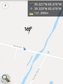
| Mon 30 May 2022 in Burney-Clay Township: 39.3211281, -85.6763848 geohashing.info google osm bing/os kml crox |
Location
In the weeds along W Co Road 100 S
Participants
Expedition
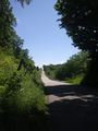
With no rain in the forecast and a full tank of gas, the path to the hashpoint spun through rural Indiana.
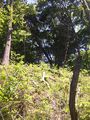
S Co Road 1050 W offered scenic parking on a 120 deg slant that taunted Clifty Creek as I walked away from my truck trying not to picture it rolling down the incline. After conversing with some moos and a semi-energetic farm dog with a lot to say and crossing Clifty Creek, I stood in the weeds along the road, gazing uphill through the bramble on the wooded edge of a farm lot adjacent to the rich riparian area along the stream - the hashpoint just out of reach on private land.
Cleaned up a bag of trash along the roadside and retrieved the front piece from some unfortunate Honda.
Photos
No further progress.
Closeish.
Looking East.
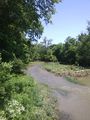
Clifty Creek.
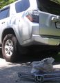
Cleanup and stuff.


