Difference between revisions of "2022-07-09 47 -118"
([live picture]Gate [https://openstreetmap.org/?mlat=47.34336400&mlon=-118.91517500&zoom=16 @47.3434,-118.9152]) |
|||
| Line 19: | Line 19: | ||
== Expedition == | == Expedition == | ||
<!-- how it all turned out. your narrative goes here. --> | <!-- how it all turned out. your narrative goes here. --> | ||
| + | Summertime is awesome. Not because it's sunny and warm, not because I'm taking time off work. It's great because I travel to the other side of the state to camp with friends - and that means multiple opportunities to geohash along the way - IF the coordinate cooperate. | ||
| + | |||
| + | I could see from the overhead map that this looked like someone's property, but it also looked like a parking area or maybe an area where livestock are moved. Heck, could even be just a field used for racing go karts. Either way, worthy of an expedition - and hopefully success. | ||
| + | |||
| + | The last part was not to be. | ||
| + | |||
| + | The area was fenced in, a simple fence, and while there were no signs indicating I couldn't enter, I respected the closed gate. Yes, if the geohash had been 2 or even 20 meters inside I probably would have gone, but 342 meters? I don't think so. I did bring a printout also, in case a farmer or rancher was in evidence to show. No luck there either. | ||
| + | |||
| + | I continued on my way. I enjoy driving down a peaceful two lane highway more than a multi lane freeway anyhow - more opportunities to see the world and even stop for ice cream. | ||
== Tracklog == | == Tracklog == | ||
| Line 38: | Line 47: | ||
<!-- Add any achievement ribbons you earned below, or remove this section --> | <!-- Add any achievement ribbons you earned below, or remove this section --> | ||
| − | |||
| − | |||
| − | |||
| − | |||
[[Category:Expeditions]] | [[Category:Expeditions]] | ||
[[Category:Expeditions with photos]] | [[Category:Expeditions with photos]] | ||
| − | |||
| − | |||
| − | |||
| − | |||
| − | |||
| − | |||
[[Category:Coordinates not reached]] | [[Category:Coordinates not reached]] | ||
| − | |||
[[Category:Not reached - No public access]] | [[Category:Not reached - No public access]] | ||
| − | |||
| − | |||
| − | |||
{{location|US|WA|LI}} | {{location|US|WA|LI}} | ||
Latest revision as of 13:25, 21 August 2022
| Sat 9 Jul 2022 in Davenport: 47.3455309, -118.9183977 geohashing.info google osm bing/os kml crox |
Location
West of Odessa on highway 28.
Participants
Plans
Quick stop on eastward journey to camping.
Expedition
Summertime is awesome. Not because it's sunny and warm, not because I'm taking time off work. It's great because I travel to the other side of the state to camp with friends - and that means multiple opportunities to geohash along the way - IF the coordinate cooperate.
I could see from the overhead map that this looked like someone's property, but it also looked like a parking area or maybe an area where livestock are moved. Heck, could even be just a field used for racing go karts. Either way, worthy of an expedition - and hopefully success.
The last part was not to be.
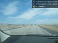
The area was fenced in, a simple fence, and while there were no signs indicating I couldn't enter, I respected the closed gate. Yes, if the geohash had been 2 or even 20 meters inside I probably would have gone, but 342 meters? I don't think so. I did bring a printout also, in case a farmer or rancher was in evidence to show. No luck there either.
I continued on my way. I enjoy driving down a peaceful two lane highway more than a multi lane freeway anyhow - more opportunities to see the world and even stop for ice cream.
Tracklog
Photos
Road @47.2263,-119.6346
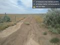
Gate @47.3434,-118.9152

