2022-08-18 59 18
From Geohashing
Revision as of 14:05, 18 August 2022 by Deep-thot (talk | contribs) ([live picture]A location in the forest just north of Angarnsjöängens nature preserve. I took a car to the northern parking lot. From there I was only about 700m from the spot. I pretty much just tried to wing my way there and started on a trail that...)
| Thu 18 Aug 2022 in 59,18: 59.5641103, 18.1742680 geohashing.info google osm bing/os kml crox |
Location
Participants
Plans
Expedition
Tracklog
Photos
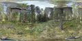
A location in the forest just north of Angarnsjöängens nature preserve.
- The location itself was in a bit of lighter forest, right on top of what seemed like an old forestry trail.
- Going back, I did the smart thing and used the local Strava heatmaps to find a much more convenient route back to the car.

Achievements