Difference between revisions of "2022-12-06 47 -122"
From Geohashing
Coyotebush (talk | contribs) ([live picture]Second visitor [https://openstreetmap.org/?mlat=47.67575556&mlon=-122.28871389&zoom=16 @47.6758,-122.2887]) |
Coyotebush (talk | contribs) ([live picture]closest screenshot) |
||
| Line 46: | Line 46: | ||
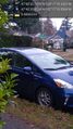
Image:2022-12-06_47_-122_coyotebush_1670357915107.jpg|Second visitor [https://openstreetmap.org/?mlat=47.67575556&mlon=-122.28871389&zoom=16 @47.6758,-122.2887] | Image:2022-12-06_47_-122_coyotebush_1670357915107.jpg|Second visitor [https://openstreetmap.org/?mlat=47.67575556&mlon=-122.28871389&zoom=16 @47.6758,-122.2887] | ||
| + | |||
| + | Image:2022-12-06_47_-122_coyotebush_1670362945999.jpg|closest screenshot | ||
</gallery> | </gallery> | ||
Revision as of 21:42, 6 December 2022
| Tue 6 Dec 2022 in 47,-122: 47.6757061, -122.2887321 geohashing.info google osm bing/os kml crox |
Location
South side of NE 65th St, between 36th and 37th Aves NE. Looks to be right on the (possibly overgrown) sidewalk.
Participants
Plans
Bike. Time TBD.
Expedition
Tracklog
Photos
Near @47.6758,-122.2888

Geohasher @47.6758,-122.2889
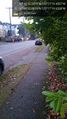
Facing east @47.6758,-122.2888
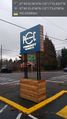
Nearby market @47.6760,-122.2849

Second visitor @47.6758,-122.2887
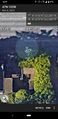
closest screenshot


Achievements