Difference between revisions of "2023-01-13 -43 172"
(Created page with "{{subst:expedition}}") |
|||
| Line 13: | Line 13: | ||
}}<!-- edit as necessary --> | }}<!-- edit as necessary --> | ||
== Location == | == Location == | ||
| − | + | In a field in Darfield, outer-outskirts of Christchurch. | |
== Participants == | == Participants == | ||
| − | + | *[[User:Stevage|Stevage]] ([[User talk:Stevage|talk]]) | |
| − | |||
| − | |||
== Plans == | == Plans == | ||
| − | + | Drive there, hop the fence, strive triumphantly to the hash. | |
== Expedition == | == Expedition == | ||
| − | + | I drove to the paddock, assuming it would behave like Australian farm hashes tend to. To wit, a huge paddock, full of grass, far from houses, with no risk of damaging anything by entering. | |
| + | |||
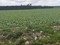
| + | After spending a few moments worrying about a field full of cows, I realised I was looking at the wrong paddock. Across the road, the field was densely planted with some kind of crop. I really don't know what, but I'll guess...beetroot. | ||
| + | |||
| + | Surprisingly, after doing dozens of farm hashes in Victoria, Australia, I've never come across a field with any crops in it. Most of the time, it's an empty paddock. Sometimes some cows or sheep. I assume that someone somewhere is growing vegetables, but they're clearly keeping it on the down low. | ||
| + | |||
| + | There was clearly no way I could get to the hash without trampling someone's crop, and that seemed mean and unjustifiable, so I sighed, and got back to driving on outer-outer-Christchurch's incredibly boring, flat, straight, narrow, and surprisingly busy roads. | ||
| − | + | It sort of feels like "no public access" isn't the right label here. The private-property nature of the farm wouldn't necessarily have kept me out, the "not wanting to damage someone's property" did. | |
| − | |||
== Photos == | == Photos == | ||
| − | |||
| − | |||
| − | |||
<gallery perrow="5"> | <gallery perrow="5"> | ||
| + | File:PXL_20230113_004109769.jpg|Glad I didn't have to deal with these fearsome monsters | ||
| + | File:PXL_20230113_003716884.jpg | ||
</gallery> | </gallery> | ||
| − | |||
| − | |||
| − | |||
| − | |||
| − | |||
| − | |||
| − | |||
| − | |||
| − | |||
| − | |||
| − | |||
| − | |||
| − | |||
| − | |||
| − | |||
| − | |||
| − | |||
| − | |||
[[Category:Expeditions]] | [[Category:Expeditions]] | ||
| − | |||
| − | |||
| − | |||
| − | |||
| − | |||
| − | |||
| − | |||
| − | |||
| − | |||
| − | |||
| − | |||
| − | |||
| − | |||
| − | |||
| − | |||
| − | |||
| − | |||
[[Category:Not reached - No public access]] | [[Category:Not reached - No public access]] | ||
| − | |||
| − | |||
| − | |||
| − | |||
| − | |||
| − | |||
| − | |||
| − | |||
Revision as of 06:02, 2 February 2023
| Fri 13 Jan 2023 in -43,172: -43.4917617, 172.0111245 geohashing.info google osm bing/os kml crox |
Contents
Location
In a field in Darfield, outer-outskirts of Christchurch.
Participants
Plans
Drive there, hop the fence, strive triumphantly to the hash.
Expedition
I drove to the paddock, assuming it would behave like Australian farm hashes tend to. To wit, a huge paddock, full of grass, far from houses, with no risk of damaging anything by entering.
After spending a few moments worrying about a field full of cows, I realised I was looking at the wrong paddock. Across the road, the field was densely planted with some kind of crop. I really don't know what, but I'll guess...beetroot.
Surprisingly, after doing dozens of farm hashes in Victoria, Australia, I've never come across a field with any crops in it. Most of the time, it's an empty paddock. Sometimes some cows or sheep. I assume that someone somewhere is growing vegetables, but they're clearly keeping it on the down low.
There was clearly no way I could get to the hash without trampling someone's crop, and that seemed mean and unjustifiable, so I sighed, and got back to driving on outer-outer-Christchurch's incredibly boring, flat, straight, narrow, and surprisingly busy roads.
It sort of feels like "no public access" isn't the right label here. The private-property nature of the farm wouldn't necessarily have kept me out, the "not wanting to damage someone's property" did.
Photos
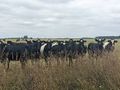
Glad I didn't have to deal with these fearsome monsters